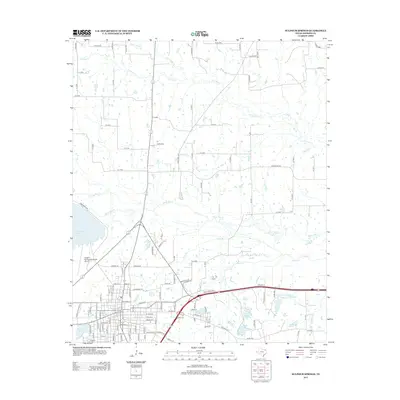
2013 Map of Sulphur Springs
USGS Topo · Published 2013About this map
Sulphur Springs Municipal Airport and the surrounding Hopkins County landscape are defined by a complex drainage network feeding into White Oak Cr. The terrain is marked by numerous small reservoirs and community-centric water bodies, including Helm Lake Number 1, Helm Lake Number 2, and Helm Lake Number 3, alongside the larger Lake Sulphur Springs and Lake Coleman. This 2013 survey illustrates the local infrastructure and land use patterns, showing how developments like the Sulphur Springs Country Club Lake and Gooding Lake are integrated into the natural hydrology. Significant tributaries such as N Caney Cr, Little Caney Cr, and Town Br weave through the region, supporting the rural and municipal needs of the community.
Find a feature on this map
124 named features on this map. Tap any name to fly to it.
Don’t see what you’re looking for? This feature index may not catch every label — zoom into the map to look around manually.
Map Details
Editions of this 2013 Sulphur Springs Map
This is the sole edition of this map. No revisions or reprints were ever made.
Other maps of this area

1953 · Texarkana
USGS Topo · 1:250,000

1956 · Texarkana
USGS Topo · 1:250,000

1962 · Sulphur Bluff
USGS Topo · 1:24,000

1962 · Brashear
USGS Topo · 1:24,000

1964 · Como
USGS Topo · 1:24,000

1964 · Sulphur Springs
USGS Topo · 1:24,000

1964 · Gafford Chapel
USGS Topo · 1:24,000

1964 · Tira
USGS Topo · 1:24,000
1964 · Cooper South
USGS Topo · 1:24,000
1964 · Sulphur Springs SE
USGS Topo · 1:24,000