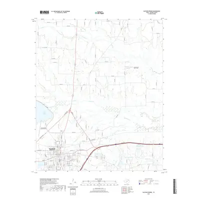
2019 Map of Sulphur Springs
USGS Topo · Published 2019About this map
Sulphur Springs, the seat of Hopkins County, occupies the southwestern portion of this map, appearing as a dense grid of streets and residential blocks north of Lake Coleman. The city's growth is oriented around several key water features, including the municipal drainage of Town Br and the nearby Lake Sulphur Springs. North of the urban center, the landscape transitions into a network of county roads and creek valleys, where White Oak Cr and its tributaries like Horse Pen Cr and Midget Cr define the drainage patterns. The prevalence of private aviation is noted by the inclusion of both the Sulphur Springs Municipal Airport and the Hidden Springs Ranch Airport. Further east, leisure and resource management are evident in features such as the Sulphur Springs Country Club Lake, Helm Lake Number 2, and Helm Lake Number 3, reflecting the region's reliance on man-made reservoirs for recreation and water storage.
Find a feature on this map
120 named features on this map. Tap any name to fly to it.
Don’t see what you’re looking for? This feature index may not catch every label — zoom into the map to look around manually.
Map Details
Editions of this 2019 Sulphur Springs Map
This is the sole edition of this map. No revisions or reprints were ever made.
Other maps of this area

1953 · Texarkana
USGS Topo · 1:250,000

1956 · Texarkana
USGS Topo · 1:250,000

1962 · Sulphur Bluff
USGS Topo · 1:24,000

1962 · Brashear
USGS Topo · 1:24,000

1964 · Como
USGS Topo · 1:24,000

1964 · Sulphur Springs
USGS Topo · 1:24,000

1964 · Gafford Chapel
USGS Topo · 1:24,000

1964 · Tira
USGS Topo · 1:24,000
1964 · Cooper South
USGS Topo · 1:24,000
1964 · Sulphur Springs SE
USGS Topo · 1:24,000