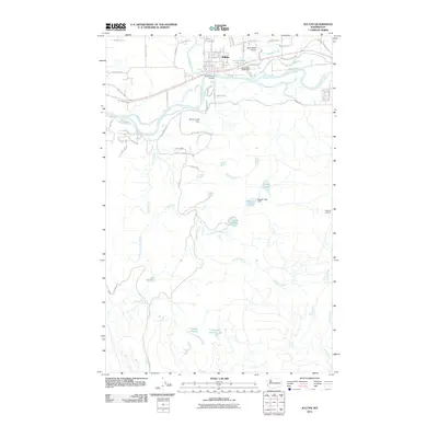
2011 Map of Sultan
USGS Topo · Published 2011About this map
Sultan stands as the primary hub where the Sultan River flows into the Skykomish River, anchoring a landscape defined by its timber and aviation infrastructure in the early 21st century. The map highlights the localized industrial footprint of the Sultan Mill Pond and its associated Sultan Mill Pond Dam, while the presence of Sky Harbor Airport northeast of the town center points to the area's role in regional general aviation. To the south, the terrain becomes increasingly remote, characterized by a complex network of water bodies such as Lake Elsie, Lake Dorothy, and the colorfully named Drunken Charlie Lake. This 2011 survey documents the transition from the settled river valley along Dyer Rd and Mann Rd to the high elevations marked by Haystack Lookout. Water management is a recurring theme throughout the quadrangle, with infrastructure like the McCoy Creek Dam and Dagger Lake Dam controlling the flow of mountain creeks toward the valley floor.
Find a feature on this map
66 named features on this map. Tap any name to fly to it.
Don’t see what you’re looking for? This feature index may not catch every label — zoom into the map to look around manually.
Map Details
Editions of this 2011 Sultan Map
This is the sole edition of this map. No revisions or reprints were ever made.
Other maps of this area

1921 · Sultan
USGS Topo · 1:125,000

1923 · Sultan
USGS Topo · 1:125,000

1953 · Sultan
USGS Topo · 1:24,000

1953 · Lake Joy
USGS Topo · 1:24,000

1953 · Monroe
USGS Topo · 1:24,000

1953 · Carnation
USGS Topo · 1:24,000

1956 · Monroe
USGS Topo · 1:62,500

1957 · Index
USGS Topo · 1:62,500

1957 · Wenatchee
USGS Topo · 1:250,000

1960 · Mount Si
USGS Topo · 1:62,500