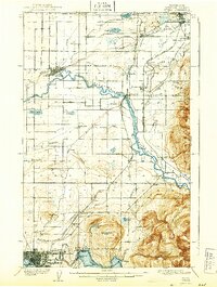
1908 Map of Sumas
USGS Topo · Published 1943About this map
The United States Canada boundary line defines the northern edge of this landscape, where the Sumas River and Nooksack River systems intersect a complex network of early 20th-century railroads. The southern reach of the map transitions from the industrial activity at Larsens Mill on Whatcom Lake to the dense street grid of Bellingham. In the rural lowlands between Lynden and Sumas, the surveyor recorded a series of specialized rail features, including a Tramway near Pangborn Lake and the Seattle and Sumas Line. Smaller farming settlements like Van Buren, Clearbrook, and Strandell are linked by the Chicago Milwaukee and St Paul RR, reflecting the region's development before modern highways reorganized the valley. Distinctive landmarks such as Squalicum Mtn and the steep slopes of Sumas Mountain provide a sharp contrast to the marshy basins of Wiser Lake and Green Lake.
Find a feature on this map
59 named features on this map. Tap any name to fly to it.
Don’t see what you’re looking for? This feature index may not catch every label — zoom into the map to look around manually.
Map Details
Editions of this 1908 Sumas Map
3 editions found
Other maps of this area

1906 · Sumas
USGS Topo · 1:62,500

1907 · Blaine
USGS Topo · 1:62,500

1908 · Sumas
USGS Topo · 1:62,500

1918 · Samish Lake
USGS Topo · 1:62,500

1919 · Van Zandt
USGS Topo · 1:62,500

1921 · Wickersham
USGS Topo · 1:62,500

1943 · Anacortes
USGS Topo · 1:62,500

1951 · Wickersham
USGS Topo · 1:62,500

1951 · Anacortes
USGS Topo · 1:62,500

1951 · Van Zandt
USGS Topo · 1:62,500