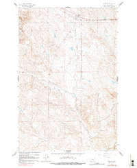
1962 Map of Sumatra
USGS Topo · Published 1991About this map
Sumatra stands as a rail-centered outpost in eastern Montana, established along the Chicago Milwaukee St Paul and Pacific railroad. This survey captures the small settlement's layout in the early 1960s, showing a cluster of activity that includes an Athletic Field and the nearby Sumatra Cem. The landscape beyond the tracks is defined by the winding course of Muggins Creek and the southern reaches of Horse Creek, where the terrain is dotted with early energy infrastructure like Oil Wells and a Drill Hole. The presence of the Kesterson Ranch reflects the enduring ranching economy of Rosebud County. This map preserves the mid-century footprint of a community whose growth was once tied to the northern transcontinental rail lines, providing a detailed look at the interface between industrial transport and rural range land.
Find a feature on this map
10 named features on this map. Tap any name to fly to it.
Don’t see what you’re looking for? This feature index may not catch every label — zoom into the map to look around manually.
Map Details
Editions of this 1962 Sumatra Map
2 editions found
Other maps of this area

1954 · Forsyth
USGS Topo · 1:250,000

1957 · Forsyth
USGS Topo · 1:250,000

1958 · Forsyth
USGS Topo · 1:250,000

1960 · Yablonski Ranch
USGS Topo · 1:24,000

1960 · Ingomar West
USGS Topo · 1:24,000

1960 · Mc Konkey Creek
USGS Topo · 1:24,000

1962 · Guthridge Ranch
USGS Topo · 1:24,000

1962 · Sumatra
USGS Topo · 1:24,000

1962 · Grebe Ranch
USGS Topo · 1:24,000

1963 · Hecker Ranch
USGS Topo · 1:24,000