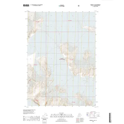
2018 Map of Sumdum A-2 NE
USGS Topo · Published 2018About this map
The Coast Mountains define this high-altitude section of the Alaskan wilderness, where massive ice fields and steep rock faces dominate the landscape. Within the boundaries of the Tongass National Forest, the map records the expansive reach of the Baird Glacier and the smaller Oasis Glacier. The terrain is characterized by intricate contour patterns that trace the vertical relief of the mountains and the frozen flows of the glacial valleys. This 2018 survey serves as a precise record of the cryosphere, showing the extent of these ice features at the time of the SPOT imagery acquisition in 2012. The absence of roads or human settlements emphasizes the primary role of this area as a preserved natural environment and a subject for glaciological study.
Find a feature on this map
10 named features on this map. Tap any name to fly to it.
Don’t see what you’re looking for? This feature index may not catch every label — zoom into the map to look around manually.
Map Details
Editions of this 2018 Sumdum A-2 NE Map
This is the sole edition of this map. No revisions or reprints were ever made.
Other maps of this area

1952 · Sumdum
USGS Topo · 1:250,000

1960 · Sumdum A-1
USGS Topo · 1:63,360

1961 · Sumdum A-2
USGS Topo · 1:63,360

1961 · Sumdum B-2
USGS Topo · 1:63,360

1961 · Sumdum
USGS Topo · 1:250,000

2000 · Sumdum A-2
USGS Topo · 1:63,360

2000 · Sumdum B-2
USGS Topo · 1:63,360
2018 · Sumdum B-2 SW
USGS Topo · 1:25,000
2018 · Sumdum A-1 NW
USGS Topo · 1:25,000
2018 · Sumdum B-2 OE E SW
USGS Topo · 1:25,000