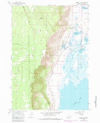
1966 Map of Summer Lake
USGS Topo · Published 1984About this map
Winter Ridge dominates the western half of this landscape, its steep escarpment dropping sharply toward the vast alkaline basin of Summer Lake. This dramatic geological transition defines the area, with the densely forested slopes of the Fremont National Forest meeting the wetlands of the Summer Lake State Wildlife Area. A notable historic line, the Old Indian Treaty Boundary, cuts diagonally across the ridge, marking a significant division in the land's colonial and indigenous history.
Find a feature on this map
26 named features on this map. Tap any name to fly to it.
Don’t see what you’re looking for? This feature index may not catch every label — zoom into the map to look around manually.
Map Details
Editions of this 1966 Summer Lake Map
Other maps of this area

1955 · Crescent
USGS Topo · 1:250,000

1955 · Klamath Falls
USGS Topo · 1:250,000

1957 · Crescent
USGS Topo · 1:250,000

1958 · Crescent
USGS Topo · 1:250,000

1958 · Klamath Falls
USGS Topo · 1:250,000

1966 · Summer Lake
USGS Topo · 1:24,000

1966 · Fremont Point
USGS Topo · 1:24,000

1966 · Pole Butte
USGS Topo · 1:24,000

1966 · Foster Butte
USGS Topo · 1:24,000

1970 · Crescent
USGS Topo · 1:250,000