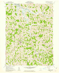
1961 Map of Summerfield
USGS Topo · Published 1963About this map
Summerfield and the surrounding hill country of Noble and Monroe Counties were heavily defined by small-scale energy extraction and agriculture in the early 1960s. The landscape is dotted with numerous gas wells and specialized industrial infrastructure, including the Berne Compressor Station Substation and a Radio Tower near the community of De Voa. Transport and utility corridors like the Pipeline cut across the high ridges, including Barnes Ridge and Lexington Ridge, while the northwestern corner of the sheet is dominated by the Senecaville Reservoir, managed by the Muskingum Watershed Conservancy District.
Find a feature on this map
57 named features on this map. Tap any name to fly to it.
Don’t see what you’re looking for? This feature index may not catch every label — zoom into the map to look around manually.
Map Details
Editions of this 1961 Summerfield Map
2 editions found
Other maps of this area

1903 · Macksburg
USGS Topo · 1:62,500

1905 · New Matamoras
USGS Topo · 1:62,500

1905 · Woodsfield
USGS Topo · 1:62,500

1905 · Macksburg
USGS Topo · 1:62,500

1909 · Summerfield
USGS Topo · 1:62,500

1911 · Summerfield
USGS Topo · 1:62,500

1924 · New Matamoras
USGS Topo · 1:62,500

1926 · New Matamoras
USGS Topo · 1:62,500

1949 · Clarksburg
USGS Topo · 1:250,000

1956 · Clarksburg
USGS Topo · 1:250,000