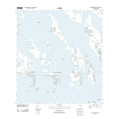
2012 Map of Summerland Key
USGS Topo · Published 2012About this map
Summerland Key and its surrounding archipelago anchor this 2012 survey, illustrating the complex geography of the Lower Florida Keys. The map details the residential and nautical development along the Old State Road 4A and Old US 1 corridors, where finger canals and private docks create a highly engineered shoreline. Significant aviation and maritime infrastructure is present, including the Summerland Key Cove Airport and several major waterways like Niles Channel and Kemp Channel.
Find a feature on this map
132 named features on this map. Tap any name to fly to it.
Don’t see what you’re looking for? This feature index may not catch every label — zoom into the map to look around manually.
Map Details
Editions of this 2012 Summerland Key Map
This is the sole edition of this map. No revisions or reprints were ever made.
Other maps of this area

1921 · Sugar Loaf Key
USGS Topo · 1:62,500

1943 · Saddlebunch Keys
USGS Topo · 1:24,000

1943 · Sugarloaf Key
USGS Topo · 1:24,000

1968 · Saddlebunch Keys
USGS Topo · 1:24,000

1972 · Big Pine Key
USGS Topo · 1:24,000

1972 · Loggerhead Key
USGS Topo · 1:24,000
1972 · Sawyer Key
USGS Topo · 1:24,000

1972 · Horseshoe Keys
USGS Topo · 1:24,000

1972 · Content Keys
USGS Topo · 1:24,000
1972 · Saddlebunch Keys
USGS Topo · 1:24,000