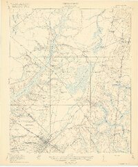
1920 Map of Summerville
USGS Topo · Published 1920About this map
The town of Summerville serves as a primary hub in this Lowcountry landscape, where the dense grid of the village meets the extensive wetlands of the Cypress Swamp and Wassamassaw Swamp. The map details a transition from established settlements like Moncks Corner and Pinopolis in the north to the research grounds of the Clemson Coast Experiment Station further south. A complex network of transit defines the region, including the Southern railroad line passing through Lincolnville and the Atlantic Coast Line running through Oakley and Strawberry. Numerous rural institutions, such as the Black Tom School and St Johns Church, are scattered across the terrain, indicating the importance of local community centers in this early 20th-century agricultural and lumbering environment.
Find a feature on this map
74 named features on this map. Tap any name to fly to it.
Don’t see what you’re looking for? This feature index may not catch every label — zoom into the map to look around manually.
Map Details
Editions of this 1920 Summerville Map
3 editions found

Other maps of this area

1918 · Cottageville
USGS Topo · 1:62,500

1919 · Ladson
USGS Topo · 1:21,120

1919 · Summerville
USGS Topo · 1:48,000

1919 · Ridgeville
USGS Topo · 1:48,000

1919 · Cordesville
USGS Topo · 1:48,000

1919 · Melgrove
USGS Topo · 1:21,120

1920 · Eutawville
USGS Topo · 1:48,000

1920 · Chicora
USGS Topo · 1:48,000

1920 · Ravenels
USGS Topo · 1:62,500

1920 · Ridgeville
USGS Topo · 1:62,500