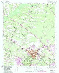
1958 Map of Summerville
USGS Topo · Published 1990About this map
Summerville and its surrounding communities sit at a transition point where the Lowcountry's extensive wetlands meet early suburban expansion. This survey captures the region as modernized transit corridors, including the path of Southern rail lines and early highway interchanges, began to reshape the rural landscape. In the north, the vast Cypress Swamp and the Black Ton Bay dominate the hydrology, feeding into numerous named branches like Smith Branch and Miller Dam Branch.
Find a feature on this map
49 named features on this map. Tap any name to fly to it.
Don’t see what you’re looking for? This feature index may not catch every label — zoom into the map to look around manually.
Map Details
Editions of this 1958 Summerville Map
4 editions found
Other maps of this area

1918 · Cottageville
USGS Topo · 1:62,500

1919 · Ladson
USGS Topo · 1:21,120

1919 · Summerville
USGS Topo · 1:48,000

1919 · Ridgeville
USGS Topo · 1:48,000

1920 · Ravenels
USGS Topo · 1:62,500

1920 · Ridgeville
USGS Topo · 1:62,500

1920 · Summerville
USGS Topo · 1:62,500

1943 · Cottageville
USGS Topo · 1:62,500

1943 · Ladson
USGS Topo · 1:24,000

1943 · Ridgeville
USGS Topo · 1:62,500