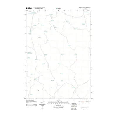
2010 Map of Summit Reservoir
USGS Topo · Published 2010About this map
Magic Reservoir dominates the northeastern corner of this high-desert landscape in Lincoln County, where a complex network of man-made catchments supports livestock and irrigation. The terrain is defined by its water management, featuring uniquely named sites such as One Hour Reservoir, Flat Tire Reservoir, and Lone Rock Reservoir. This intricate system of small impoundments, often located at the terminus of dry washes or seasonal drainages, illustrates the critical importance of water storage in Idaho's arid interior. To the south, the prominent Black Butte rises as a significant navigational landmark, while historical infrastructure like Dry Wash Dam and access routes including Buck Lake Desert Rd reveal the human efforts to settle and utilize this environment. Natural water sources like Tom Gooding Spring and Marsh Spring provide a contrast to the engineered reservoirs scattered across the quadrangle.
Find a feature on this map
41 named features on this map. Tap any name to fly to it.
Don’t see what you’re looking for? This feature index may not catch every label — zoom into the map to look around manually.
Map Details
Editions of this 2010 Summit Reservoir Map
This is the sole edition of this map. No revisions or reprints were ever made.
Other maps of this area

1955 · Hailey
USGS Topo · 1:250,000

1957 · Thorn Creek SE
USGS Topo · 1:24,000

1957 · Thorn Creek
USGS Topo · 1:62,500

1957 · Bellevue
USGS Topo · 1:62,500

1957 · Blaine
USGS Topo · 1:62,500

1959 · Hailey
USGS Topo · 1:250,000

1962 · Hailey
USGS Topo · 1:250,000

1979 · Shoshone Ice Cave
USGS Topo · 1:24,000
1979 · Kinzie Butte
USGS Topo · 1:24,000

1979 · Summit Reservoir
USGS Topo · 1:24,000