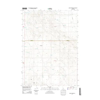
2013 Map of Summit Reservoir
USGS Topo · Published 2013About this map
Mount Bennett Hills and the surrounding volcanic plateau define this high-desert landscape along the border of Camas and Lincoln counties. The terrain is characterized by a high density of small-scale water management features, including dozens of earthen impoundments like Summit Reservoir, Granite Butte Reservoir, and Shoshone Reservoir. These basins, often named for local figures or topography such as Daves Reservoir or Cirque Reservoir, imply a history of seasonal grazing and water security in a semi-arid environment. The presence of Black Butte and the Black Butte Hills in the southwest corner signals the region's geological transition toward the lava-scarred plains. While primary roads like Cottonwoods Rd provide access in the east, the interior is dominated by natural springs such as Tom Gooding Spring and Marsh Spring, which likely served as critical landmarks for early travelers and ranchers crossing this elevated terrain.
Find a feature on this map
43 named features on this map. Tap any name to fly to it.
Don’t see what you’re looking for? This feature index may not catch every label — zoom into the map to look around manually.
Map Details
Editions of this 2013 Summit Reservoir Map
This is the sole edition of this map. No revisions or reprints were ever made.
Other maps of this area

1955 · Hailey
USGS Topo · 1:250,000

1957 · Thorn Creek SE
USGS Topo · 1:24,000

1957 · Thorn Creek
USGS Topo · 1:62,500

1957 · Bellevue
USGS Topo · 1:62,500

1957 · Blaine
USGS Topo · 1:62,500

1959 · Hailey
USGS Topo · 1:250,000

1962 · Hailey
USGS Topo · 1:250,000

1979 · Shoshone Ice Cave
USGS Topo · 1:24,000
1979 · Kinzie Butte
USGS Topo · 1:24,000

1979 · Summit Reservoir
USGS Topo · 1:24,000