
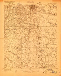
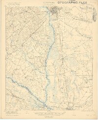
1990 Map of Sumter
USGS Topo · Published 1990About this map
The confluence of the Wateree River and the Congaree River forms the upper reaches of the Santee River in this detailed 1990 survey of central South Carolina. This low-lying landscape is defined by the massive Congaree Swamp National Monument, which preserves a critical stretch of floodplain forest. To the east, the rising terrain of the Sandhills supports the Manchester State Forest and the nearby Poinsett State Park, illustrating the transition from swampy bottomlands to upland pine woods.
Find a feature on this map
79 named features on this map. Tap any name to fly to it.
Don’t see what you’re looking for? This feature index may not catch every label — zoom into the map to look around manually.
Map Details
Editions of this 1990 Sumter Map
This is the sole edition of this map. No revisions or reprints were ever made.
Other maps of this area

1904 · Columbia
USGS Topo · 1:125,000

1919 · Bamberg
USGS Topo · 1:48,000

1920 · Eutawville
USGS Topo · 1:48,000

1920 · Chicora
USGS Topo · 1:48,000

1920 · Bowman
USGS Topo · 1:48,000

1920 · Mayesville
USGS Topo · 1:48,000

1920 · Manning
USGS Topo · 1:48,000

1920 · Bamberg
USGS Topo · 1:62,500
1920 · Orangeburg
USGS Topo · 1:48,000
1921 · Orangeburg
USGS Topo · 1:62,500