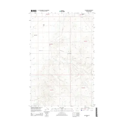
2014 Map of Sun Prairie
USGS Topo · Published 2014About this map
Sun Prairie and the surrounding high plains of Phillips County define this 2014 landscape, where the vast Sun Prairie Flats transition into a complex network of coulees and creeks. The drainage patterns are a primary feature of the topography, with Box Elder Coulee and Dog Cr carving through the northern sections while Telegraph Cr and Smith Cr define the southern reaches. This modern survey illustrates how infrastructure in this part of Montana remains focused on remote connectivity, evidenced by routes such as Fourchette Bay Rd and Content Rd. The map provides a precise look at the township and range system, showing the boundaries between t25n r31e and t24n r32e, marking out the grid of a sparsely populated ranching and grazing region.
Find a feature on this map
17 named features on this map. Tap any name to fly to it.
Don’t see what you’re looking for? This feature index may not catch every label — zoom into the map to look around manually.
Map Details
Editions of this 2014 Sun Prairie Map
This is the sole edition of this map. No revisions or reprints were ever made.
Other maps of this area

1954 · Jordan
USGS Topo · 1:250,000

1956 · Jordan
USGS Topo · 1:250,000

1958 · Jordan
USGS Topo · 1:250,000

1964 · Jordan
USGS Topo · 1:250,000

1965 · Coal Mine Hill
USGS Topo · 1:24,000

1965 · Sun Prairie
USGS Topo · 1:24,000

1965 · Herman Point
USGS Topo · 1:24,000

1965 · Whitcomb Lake
USGS Topo · 1:24,000
1965 · Stratton Reservoir
USGS Topo · 1:24,000

1965 · Schuyler Butte
USGS Topo · 1:24,000