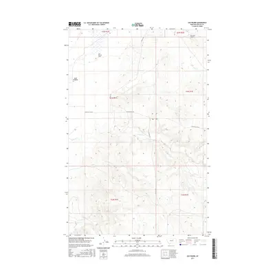
2017 Map of Sun Prairie
USGS Topo · Published 2017About this map
Sun Prairie and its surrounding plains are documented in this 2017 U.S. Geological Survey topographic map, illustrating the open terrain of Phillips County. The landscape is defined by its drainages, most notably Box Elder Coulee, which carves through the northern portion of the quadrangle. This area of Montana is characterized by wide-ranging land divisions and a sparse settlement pattern typical of the high plains. Researchers can study the relationship between the few named geographical features and the grid of local roads that provide access to this remote region. The map provides an essential baseline for understanding contemporary land use and topographic relief in a section of the state where water features and small communities dictate the local geography.
Find a feature on this map
2 named features on this map. Tap any name to fly to it.
Don’t see what you’re looking for? This feature index may not catch every label — zoom into the map to look around manually.
Map Details
Editions of this 2017 Sun Prairie Map
This is the sole edition of this map. No revisions or reprints were ever made.
Other maps of this area

1954 · Jordan
USGS Topo · 1:250,000

1956 · Jordan
USGS Topo · 1:250,000

1958 · Jordan
USGS Topo · 1:250,000

1964 · Jordan
USGS Topo · 1:250,000

1965 · Coal Mine Hill
USGS Topo · 1:24,000

1965 · Sun Prairie
USGS Topo · 1:24,000

1965 · Herman Point
USGS Topo · 1:24,000

1965 · Whitcomb Lake
USGS Topo · 1:24,000
1965 · Stratton Reservoir
USGS Topo · 1:24,000

1965 · Schuyler Butte
USGS Topo · 1:24,000