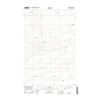
2014 Map of Sundance
USGS Topo · Published 2014About this map
Seville Colony sits at the heart of this High Plains landscape, where the topography is defined by the winding course of Cut Bank Creek. The drainage patterns of the region are clearly visible through features like Gillam Coulee and Wasteway Coulee, which carve into the terrain near the plateau of Seville Flat. This area in Glacier County reflects a ranching and agricultural economy, emphasized by a grid of rural roads and water management features such as the Q Lateral. Local travel and property boundaries are anchored by established routes including Pardue Rd and Johnson Rd, which connect the scattered homesteads across the townships. The map provides a detailed look at the water resources of the Blackfeet Reservation area, from the South Fork Little Rock Coulee in the north to the irrigation-influenced plains in the south.
Find a feature on this map
17 named features on this map. Tap any name to fly to it.
Don’t see what you’re looking for? This feature index may not catch every label — zoom into the map to look around manually.
Map Details
Editions of this 2014 Sundance Map
This is the sole edition of this map. No revisions or reprints were ever made.
Other maps of this area

1907 · Blackfoot Res.
USGS Topo · 1:48,000

1909 · Cut Bank
USGS Topo · 1:125,000

1911 · Blackfoot
USGS Topo · 1:125,000

1912 · Cut Bank
USGS Topo · 1:125,000

1960 · Cut Bank
USGS Topo · 1:250,000

1963 · Cut Bank
USGS Topo · 1:250,000

1964 · Cut Bank
USGS Topo · 1:250,000
1966 · Squaw Buttes
USGS Topo · 1:24,000
1966 · Gunsight
USGS Topo · 1:24,000

1968 · Buffalo Lake
USGS Topo · 1:24,000