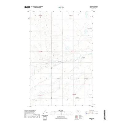
2020 Map of Sundance
USGS Topo · Published 2020About this map
Sundance occupies a quiet stretch of Glacier County, Montana, where the terrain transitions toward the level expanse of Seville Flat to the south. This 2020 survey records a landscape defined by its drainages, most notably the winding course of Cut Bank Creek and its various tributaries such as Gillam Coulee and South Fork Little Rock Coulee. The presence of Wasteway Coulee and the precisely named 34No7W30BCAC01 Spring suggests a reliance on specific water sources in this semi-arid environment. The rural infrastructure is traced by local routes like Johnson Rd and Gunsight Rd, along with the Q Lateral irrigation feature, reflecting the area's agricultural and ranching character. The map also delineates several township and range boundaries, including t34n r7w and t35n r8w, providing a clear grid for property research and land management in the region.
Find a feature on this map
16 named features on this map. Tap any name to fly to it.
Don’t see what you’re looking for? This feature index may not catch every label — zoom into the map to look around manually.
Map Details
Editions of this 2020 Sundance Map
This is the sole edition of this map. No revisions or reprints were ever made.
Other maps of this area

1907 · Blackfoot Res.
USGS Topo · 1:48,000

1909 · Cut Bank
USGS Topo · 1:125,000

1911 · Blackfoot
USGS Topo · 1:125,000

1912 · Cut Bank
USGS Topo · 1:125,000

1960 · Cut Bank
USGS Topo · 1:250,000

1963 · Cut Bank
USGS Topo · 1:250,000

1964 · Cut Bank
USGS Topo · 1:250,000
1966 · Squaw Buttes
USGS Topo · 1:24,000
1966 · Gunsight
USGS Topo · 1:24,000

1968 · Buffalo Lake
USGS Topo · 1:24,000