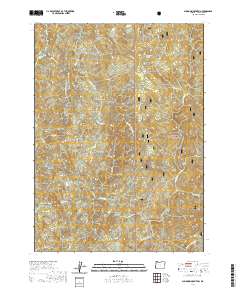
2020 Map of Sundown Mountain
USGS Topo · Published 2020About this map
Siskiyou National Forest covers much of this Curry County landscape, where the drainage systems of Hunter Creek and the Pistol River meet. The terrain is defined by prominent peaks and geological markers, including the central summit of Sundown Mtn and the northern Pyramid Rock. Water is a persistent theme throughout the territory, with features like Hunter Creek Bog and Flycatcher Spring highlighting the coastal mountain hydrology. The map provides a detailed view of the forest's interior infrastructure, showing numerous service routes such as Nat For Dev Rd 1703 and N Bank Pistol River Rd that navigate the steep elevations near Red Flat and Pine Point. Towards the southern edge, the confluence of Koontz and Davis Cr with the S Fork Pistol River illustrates the complex network of minor tributaries that feed this river system.
Find a feature on this map
31 named features on this map. Tap any name to fly to it.
Don’t see what you’re looking for? This feature index may not catch every label — zoom into the map to look around manually.
Map Details
Editions of this 2020 Sundown Mountain Map
This is the sole edition of this map. No revisions or reprints were ever made.
Other maps of this area

1954 · Coos Bay
USGS Topo · 1:250,000

1954 · Cape Ferrelo
USGS Topo · 1:62,500

1954 · Gold Beach
USGS Topo · 1:62,500

1954 · Collier Butte
USGS Topo · 1:62,500

1954 · Mt. Emily
USGS Topo · 1:62,500

1958 · Coos Bay
USGS Topo · 1:250,000

1962 · Coos Bay
USGS Topo · 1:250,000
1985 · Mack Point
USGS Topo · 1:24,000
1986 · Carpenterville
USGS Topo · 1:24,000
1986 · Sundown Mtn
USGS Topo · 1:24,000