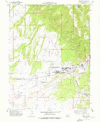
1972 Map of Sunnyside
USGS Topo · Published 1976About this map
The industrial coal-mining landscape of eastern Utah is sharply defined by the interconnected communities of East Carbon City, Sunnyside, and Dragerton. This 1970s record showcases the complex infrastructure of a high-desert mining district, where the Denver and Rio Grande Western and Carbon County Railway serve a series of operations, including the prominent Coke Ovens and several Mines tucked into the canyons. The geography is dominated by the massive West Ridge and the Clark Valley, with water management clearly prioritized through the Grassy Trail Reservoir and various Springs. The social fabric of these company towns is visible through local institutions like East Carbon High School and the Petersen School, while the spatial layout of Columbia further south illustrates the linear development common in these narrow canyon corridors.
Find a feature on this map
40 named features on this map. Tap any name to fly to it.
Don’t see what you’re looking for? This feature index may not catch every label — zoom into the map to look around manually.
Map Details
Editions of this 1972 Sunnyside Map
2 editions found
Other maps of this area

1886 · Price River
USGS Topo · 1:250,000

1896 · Price River
USGS Topo · 1:250,000

1915 · Sunnyside
USGS Topo · 1:62,500

1915 · Wellington
USGS Topo · 1:62,500

1948 · Woodside
USGS Topo · 1:62,500

1949 · Woodside
USGS Topo · 1:62,500

1950 · Woodside
USGS Topo · 1:62,500

1956 · Price
USGS Topo · 1:250,000

1960 · Price
USGS Topo · 1:250,000

1962 · Price
USGS Topo · 1:250,000