
1974 Map of Sunray 1 NW
USGS Topo · Published 1977About this map
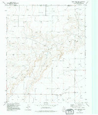
The rugged topography along Frisco Creek dominates this landscape in the mid-1970s, where deep erosion patterns cut through the high plains of the Texas Panhandle. Located along the northern border of Sherman Co, the terrain transitions from flat agricultural and energy-producing lands into the drainage system of the creek. Evidence of the region’s mid-century economic drivers is visible throughout, notably in the network of Pipeline and Pipelines that traverse the quadrangle, alongside a Pumping Sta supporting local infrastructure. While primarily open country, the map documents specific industrial sites like the Gravel Pit and Gravel Pits, providing a precise record of land use and resource extraction at the time of the 1974 field check.
Find a feature on this map
8 named features on this map. Tap any name to fly to it.
Don’t see what you’re looking for? This feature index may not catch every label — zoom into the map to look around manually.
Map Details
Editions of this 1974 Sunray 1 NW Map
2 editions found
Other maps of this area

1954 · Perryton
USGS Topo · 1:250,000

1958 · Perryton
USGS Topo · 1:250,000

1973 · Goodwell SE
USGS Topo · 1:24,000

1973 · Texhoma North
USGS Topo · 1:24,000

1973 · Goodwell
USGS Topo · 1:24,000

1974 · Texhoma South
USGS Topo · 1:24,000

1974 · Stevens SE
USGS Topo · 1:24,000

1974 · Sunray 1 SW
USGS Topo · 1:24,000

1974 · Sunray 1 SE
USGS Topo · 1:24,000

1974 · Sunray 1 NE
USGS Topo · 1:24,000