
1974 Map of Sunray 1 SE
USGS Topo · Published 1977About this map
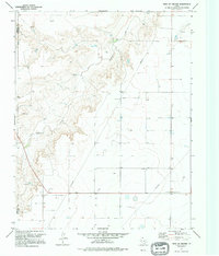
Coldwater Creek carves a dramatic, branching system of draws through the High Plains along the Sherman and Hansford County line. In the mid-1970s, this landscape was defined by the industrial footprint of the Texas Panhandle's energy sector. A network of Pipelines crisscrosses the flat upland terrain, connecting numerous Gas Wells and an Oil Well to a central Pumping Sta. The contrast between the deeply eroded creek bed and the geometric precision of the section lines and energy infrastructure illustrates the regional dependence on subsurface resources. Aside from a lone Gravel Pit, the map shows a sparsely populated area where the primary human activity was centered on resource extraction and transport across the open prairie.
Find a feature on this map
8 named features on this map. Tap any name to fly to it.
Don’t see what you’re looking for? This feature index may not catch every label — zoom into the map to look around manually.
Map Details
Editions of this 1974 Sunray 1 SE Map
2 editions found
Other maps of this area

1954 · Perryton
USGS Topo · 1:250,000

1958 · Perryton
USGS Topo · 1:250,000

1973 · Gruver
USGS Topo · 1:24,000

1974 · Sunray 1 NW
USGS Topo · 1:24,000

1974 · Hannas Draw East
USGS Topo · 1:24,000

1974 · Sunray 1 SW
USGS Topo · 1:24,000

1974 · Capps Switch NW
USGS Topo · 1:24,000

1974 · Hannas Draw West
USGS Topo · 1:24,000

1974 · Sunray 1 NE
USGS Topo · 1:24,000
1974 · Phillips Camp
USGS Topo · 1:24,000