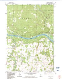
1983 Map of Sunrise
USGS Topo · Published 1984About this map
The St Croix River carves a deep valley between Minnesota and Wisconsin, defining the character of this landscape in the early 1980s. Along the western banks, the settlement of Sunrise serves as a focal point for local history, located near the Sunrise Cem and the confluence where the Sunrise River meets the main channel. The presence of an Old Railroad Grade and the Sunrise Ferry Hiking Trail indicates the historical importance of this river crossing and the evolution of transportation in the St. Croix Valley. Much of the land is dedicated to conservation and recreation, falling within the Governor Knowles State Forest and the St Croix National Scenic Riverway. In the uplands, scattered Gravel Pits and drainages like Cowan Creek and the Trade River mark a terrain shaped by glacial activity and rural agriculture.
Find a feature on this map
24 named features on this map. Tap any name to fly to it.
Don’t see what you’re looking for? This feature index may not catch every label — zoom into the map to look around manually.
Map Details
Editions of this 1983 Sunrise Map
2 editions found
Other maps of this area

1900 · St Croix Dalles
USGS Topo · 1:62,500

1901 · St Croix Dalles
USGS Topo · 1:62,500

1950 · Rush City
USGS Topo · 1:48,000

1951 · Milltown
USGS Topo · 1:48,000

1953 · Stillwater
USGS Topo · 1:250,000

1955 · St. Croix Dalles
USGS Topo · 1:62,500

1955 · Rush City
USGS Topo · 1:62,500

1955 · Milltown
USGS Topo · 1:62,500

1955 · Forest Lake
USGS Topo · 1:62,500

1955 · Stillwater
USGS Topo · 1:250,000