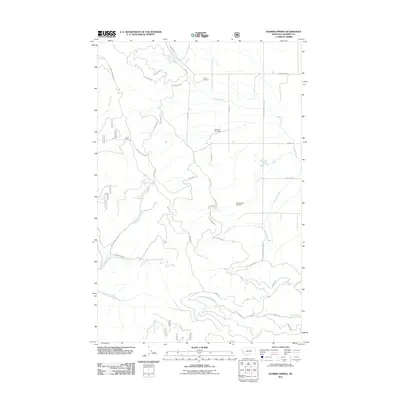
2011 Map of Sunrise Spring
USGS Topo · Published 2011About this map
Pluffe Cemetery, Hoministo Cemetery, and the Camas Prairie Cemetery stand as quiet landmarks across this Sanders County landscape, marking the historic presence of rural communities in western Montana. The terrain is defined by a dense network of watercourses, including Camas Creek, McLaughlin Creek, and Micharl Creek, which descend from higher elevations toward the lower valleys. This 2011 survey documents a complex system of Forest Service and local roads, such as McLaughlin Rd and Cottonwood Creek Rd, that provide access to the area’s interior and the Sunrise Spring. The map captures the transition between the managed forest lands and the open drainage basins, preserving the names of family-named landmarks and essential water sources like Clear Creek and Henry Creek at the start of the twenty-first century.
Find a feature on this map
37 named features on this map. Tap any name to fly to it.
Don’t see what you’re looking for? This feature index may not catch every label — zoom into the map to look around manually.
Map Details
Editions of this 2011 Sunrise Spring Map
This is the sole edition of this map. No revisions or reprints were ever made.
Other maps of this area

1956 · Wallace
USGS Topo · 1:250,000

1959 · Perma
USGS Topo · 1:62,500

1959 · Plains
USGS Topo · 1:62,500

1960 · Wallace
USGS Topo · 1:250,000

1964 · Markle Pass
USGS Topo · 1:24,000

1964 · Baldy Lake
USGS Topo · 1:24,000

1964 · Hot Springs
USGS Topo · 1:24,000
1980 · Polson
USGS Topo · 1:100,000
1984 · Paradise
USGS Topo · 1:24,000
1984 · Sunrise Spring
USGS Topo · 1:24,000