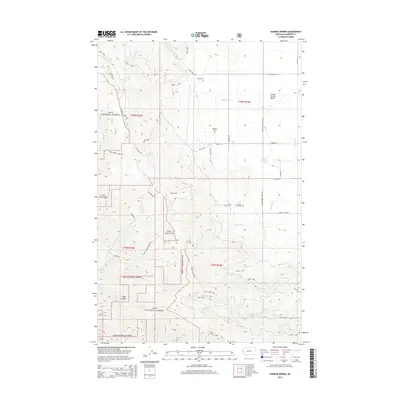
2014 Map of Sunrise Spring
USGS Topo · Published 2014About this map
Lolo National Forest encompasses the western and southern reaches of this landscape, where the terrain breaks into steep drainages like Hugo Canyon and Clear Creek Cyn. In the northeastern section, the land opens into the Camas Prairie Basin, a distinct topographical contrast to the timbered ridges. This area is characterized by a network of watercourses including Camas Cr and Michael Cr, which define the local watershed patterns.
Find a feature on this map
38 named features on this map. Tap any name to fly to it.
Don’t see what you’re looking for? This feature index may not catch every label — zoom into the map to look around manually.
Map Details
Editions of this 2014 Sunrise Spring Map
This is the sole edition of this map. No revisions or reprints were ever made.
Other maps of this area

1956 · Wallace
USGS Topo · 1:250,000

1959 · Perma
USGS Topo · 1:62,500

1959 · Plains
USGS Topo · 1:62,500

1960 · Wallace
USGS Topo · 1:250,000

1964 · Markle Pass
USGS Topo · 1:24,000

1964 · Baldy Lake
USGS Topo · 1:24,000

1964 · Hot Springs
USGS Topo · 1:24,000
1980 · Polson
USGS Topo · 1:100,000
1984 · Paradise
USGS Topo · 1:24,000
1984 · Sunrise Spring
USGS Topo · 1:24,000