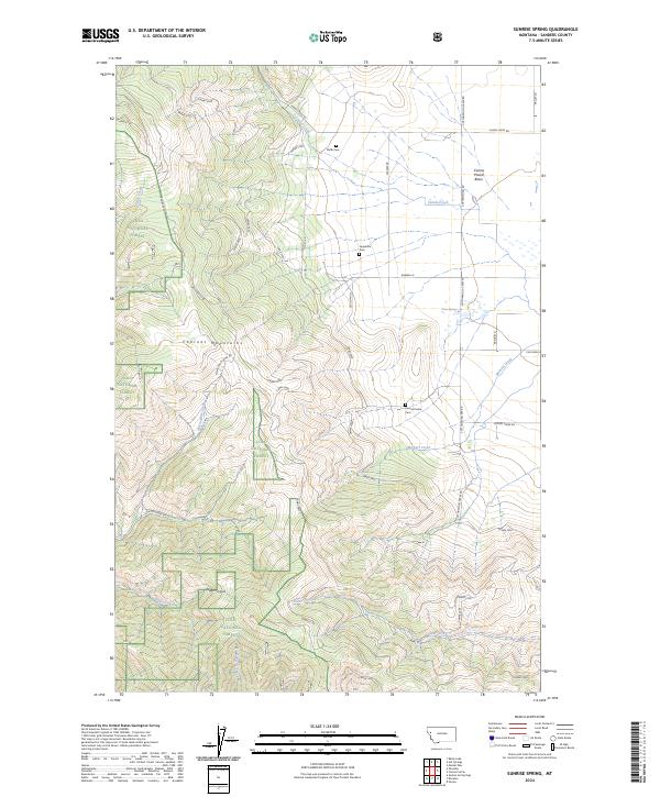
2024 Map of Sunrise Spring
USGS Topo · Published 2024About this map
Camas Prairie Basin serves as the focal point of this landscape, where the flat floor of the basin meets the rising slopes of the Cabinet Mountains. The area is defined by a network of drainage systems including Camas Creek and Micharl Creek, which flow through a mix of open land and the wooded reaches of the Lolo National Forest. For genealogists and local historians, the map is particularly valuable for its placement of three distinct burial grounds: Pluffe Cem, Hoministo Cem, and the Camas Prairie Cem. These sites, along with family-named landmarks like Green Springs and Sunrise Spring, offer a clear look at the settlement patterns in this part of Sanders County. The transition from the rugged Hugo Canyon to the structured grid of forest service roads like Camas 6000 illustrates the intersection of natural topography and land management.
Find a feature on this map
50 named features on this map. Tap any name to fly to it.
Don’t see what you’re looking for? This feature index may not catch every label — zoom into the map to look around manually.
Map Details
Editions of this 2024 Sunrise Spring Map
This is the sole edition of this map. No revisions or reprints were ever made.
Other maps of this area

1956 · Wallace
USGS Topo · 1:250,000

1959 · Perma
USGS Topo · 1:62,500

1959 · Plains
USGS Topo · 1:62,500

1960 · Wallace
USGS Topo · 1:250,000

1964 · Markle Pass
USGS Topo · 1:24,000

1964 · Baldy Lake
USGS Topo · 1:24,000

1964 · Hot Springs
USGS Topo · 1:24,000
1980 · Polson
USGS Topo · 1:100,000
1984 · Paradise
USGS Topo · 1:24,000
1984 · Sunrise Spring
USGS Topo · 1:24,000