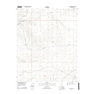
2014 Map of Sunrise Springs
USGS Topo · Published 2014About this map
Sunrise Springs is the primary point of reference in this landscape within the Fort Defiance Agency, situated at the confluence of several local transportation routes including Navajo Station Rd and Bia-15. The terrain is characterized by complex drainage patterns, with Ruins Wash and Big Wilderness Wash cutting through the western portion of the quadrangle. North of the settlement, Ruins Ridge stands as a prominent topographic feature, while the southern reaches of the map show the impact of water management through the presence of the Big Dam Reservoir. A network of Bureau of Indian Affairs routes, such as Bia-28 and Bia-9152, provide a detailed record of the rural infrastructure connecting disparate homesteads and natural resources across this high-desert environment in Apache County.
Find a feature on this map
23 named features on this map. Tap any name to fly to it.
Don’t see what you’re looking for? This feature index may not catch every label — zoom into the map to look around manually.
Map Details
Editions of this 2014 Sunrise Springs Map
This is the sole edition of this map. No revisions or reprints were ever made.
Other maps of this area

1886 · Fort Defiance
USGS Topo · 1:250,000

1892 · Fort Defiance
USGS Topo · 1:250,000

1954 · Gallup
USGS Topo · 1:250,000

1958 · Gallup
USGS Topo · 1:250,000

1959 · Gallup
USGS Topo · 1:250,000

1962 · Gallup
USGS Topo · 1:250,000

1967 · Gallup
USGS Topo · 1:250,000
1972 · Steamboat Canyon
USGS Topo · 1:24,000
1972 · Greasewood
USGS Topo · 1:24,000
1972 · Boggy Lake Well
USGS Topo · 1:24,000
Featured Places
- Fort Defiance Agency
- Kin Łigaaí, Fort Defiance Agency
- Ałchʼįʼáhootʼé, Fort Defiance Agency
- Sunrise Springs, Fort Defiance Agency
- Apache County, AZ