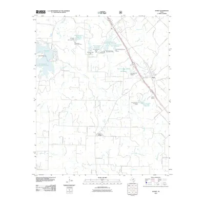
2010 Map of Sunset
USGS Topo · Published 2010About this map
Sunset and Park Springs anchor this portion of Montague County, where the landscape is defined by an extensive water management system. Numerous reservoirs, such as Soil Conservation Service Site 13 Reservoir and Soil Conservation Service Site 11 Reservoir, are distributed across the drainage basins of Big Sandy Creek and Turkey Creek. This network of dams, including the Big Sandy Creek Dam Number 11, illustrates a modern era of coordinated watershed protection and flood control in North Texas. The northwestern corner is dominated by Lake Amon G Carter, held by the Amon G Carter Dam. Local history is preserved at the Sunset Beasley Cemetery near the junction of several county roads. The map detail extends to individual properties and a dense network of rural routes like Fruit Land Rd and Picket Run Rd, providing a clear record of the area's rural development and land use patterns.
Find a feature on this map
79 named features on this map. Tap any name to fly to it.
Don’t see what you’re looking for? This feature index may not catch every label — zoom into the map to look around manually.
Map Details
Editions of this 2010 Sunset Map
This is the sole edition of this map. No revisions or reprints were ever made.
Other maps of this area

1905 · Montague
USGS Topo · 1:125,000

1954 · Sherman
USGS Topo · 1:250,000

1958 · Sherman
USGS Topo · 1:250,000

1961 · Salona
USGS Topo · 1:24,000

1961 · Brushy Mound
USGS Topo · 1:24,000

1961 · Selma
USGS Topo · 1:24,000

1961 · Alvord
USGS Topo · 1:24,000

1961 · Sunset
USGS Topo · 1:24,000
1961 · Smyrna
USGS Topo · 1:24,000

1961 · Bowie
USGS Topo · 1:24,000