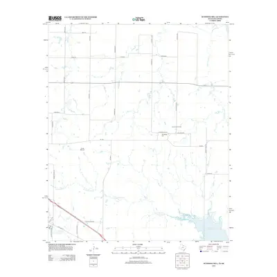
2012 Map of Sunshine Hill
USGS Topo · Published 2012About this map
Sunshine Hill Oil Field defines much of the industrial character in this part of Wichita County, a landscape where energy extraction and prairie ranching intersect. The settlement of Sunshine Hill sits at the heart of this activity, surrounded by a network of ranch roads and loops such as McClure Loop and Barwise Rd. To the west, Floral Mound provides a distinct geographical landmark amidst the drainages of Long Cr and Cole Cr.
Find a feature on this map
35 named features on this map. Tap any name to fly to it.
Don’t see what you’re looking for? This feature index may not catch every label — zoom into the map to look around manually.
Map Details
Editions of this 2012 Sunshine Hill Map
This is the sole edition of this map. No revisions or reprints were ever made.
Other maps of this area

1915 · Clara
USGS Topo · 1:24,000

1915 · Barwise School
USGS Topo · 1:24,000

1916 · Electra
USGS Topo · 1:24,000

1916 · Iowa Park
USGS Topo · 1:24,000

1916 · Fowlkes
USGS Topo · 1:24,000

1917 · Beaver Creek
USGS Topo · 1:24,000

1918 · Electra
USGS Topo · 1:31,680

1918 · Barwise School
USGS Topo · 1:31,680

1918 · Clara
USGS Topo · 1:31,680

1918 · Iowa Park
USGS Topo · 1:31,680