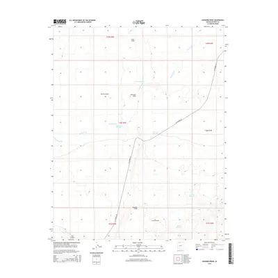
2014 Map of Sunshine Ridge
USGS Topo · Published 2014About this map
Sunshine Ridge and the surrounding high desert of Mohave County are defined here by a vital network of water catchment systems and seasonal drainages. During this early 21st-century period, the landscape’s utility is centered on man-made features like Cañon Reservoir, Wild Band Reservoir, and CCC Trail Reservoir, which signify the area's importance for range management and livestock. These small water sources are strategically positioned along the primary transit corridor of Mt Trumbull Rd, which cuts through the center of the sheet. The terrain is marked by significant geographic depressions including Bulrush Canyon and Wild Band Valley, which funnel seasonal runoff into the Bulrush Wash. This map provides a clear record of the essential infrastructure required to sustain activity in this arid region, from the Tom Lamb Reservoir to the depths of Grama Canyon.
Find a feature on this map
20 named features on this map. Tap any name to fly to it.
Don’t see what you’re looking for? This feature index may not catch every label — zoom into the map to look around manually.
Map Details
Editions of this 2014 Sunshine Ridge Map
This is the sole edition of this map. No revisions or reprints were ever made.
Other maps of this area

1886 · Kaibab
USGS Topo · 1:250,000

1953 · Grand Canyon
USGS Topo · 1:250,000

1954 · Heaton Knolls NW
USGS Topo · 1:24,000
1954 · Short Creek SW
USGS Topo · 1:24,000

1954 · Short Creek SE
USGS Topo · 1:24,000

1954 · Heaton Knolls SE
USGS Topo · 1:24,000

1954 · Fredonia SW
USGS Topo · 1:24,000

1954 · Fredonia
USGS Topo · 1:62,500

1954 · Short Creek
USGS Topo · 1:62,500

1954 · Heaton Knolls
USGS Topo · 1:62,500