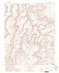
1988 Map of Supai
USGS Topo · Published 1988About this map
Supai serves as the focal point of this 1980s landscape, situated within the Havasupai Indian Reservation where the perennial waters of Havasu Creek flow toward the north. The settlement is positioned near unique cultural and topographical landmarks like the Wigleeva rock formations and the cascading Navajo Falls. Local history is anchored by the Navajo Falls Cem and other designated Cems near the village, indicating long-standing occupation in this isolated canyon environment.
Find a feature on this map
33 named features on this map. Tap any name to fly to it.
Don’t see what you’re looking for? This feature index may not catch every label — zoom into the map to look around manually.
Map Details
Editions of this 1988 Supai Map
2 editions found
Other maps of this area

1886 · Kaibab
USGS Topo · 1:250,000

1953 · Grand Canyon
USGS Topo · 1:250,000

1957 · Grand Canyon
USGS Topo · 1:250,000

1958 · Grand Canyon
USGS Topo · 1:250,000

1960 · Grand Canyon
USGS Topo · 1:250,000

1962 · Kanab Point
USGS Topo · 1:62,500

1962 · Tuckup Canyon
USGS Topo · 1:62,500

1962 · Supai
USGS Topo · 1:62,500

1962 · National Canyon
USGS Topo · 1:62,500

1984 · Grand Canyon
USGS Topo · 1:100,000