
1947 Map of Surf
USGS Topo · Published 1948About this map
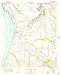
The Camp Cooke Military Reservation dominates this coastal landscape during the immediate post-war era, showcasing the massive infrastructure of wartime mobilization along the Pacific Ocean. This military footprint is layered over an older agrarian and transit-based economy, where the Southern Pacific railroad follows the coastline, passing through the seaside stop at Surf and the junction at Weser Spur. The land use transition is evident in the presence of scattered Gravel Pits and Oil symbols adjacent to the base. Inland, the Santa Ynez River meanders toward the sea, flanked by the Mission Purisima historic site. Small rural community centers like Artesia Sch and the settlement of La Salle provide points of interest for genealogists tracing the pre-suburban development of Santa Barbara County, while the topographical detail of Burton Mesa and Lompoc Canyon reveals the natural barriers that shaped local transport.
Find a feature on this map
29 named features on this map. Tap any name to fly to it.
Don’t see what you’re looking for? This feature index may not catch every label — zoom into the map to look around manually.
Map Details
Editions of this 1947 Surf Map
2 editions found
Other maps of this area

1905 · Guadalupe
USGS Topo · 1:125,000

1905 · Lompoc
USGS Topo · 1:125,000

1942 · Point Arguello
USGS Topo · 1:62,500

1942 · Guadalupe
USGS Topo · 1:125,000

1942 · Lompoc
USGS Topo · 1:125,000

1942 · Lompoc
USGS Topo · 1:62,500

1942 · Santa Maria
USGS Topo · 1:62,500

1942 · Point Sal
USGS Topo · 1:62,500

1943 · Lompoc
USGS Topo · 1:125,000

1947 · Lompoc
USGS Topo · 1:24,000