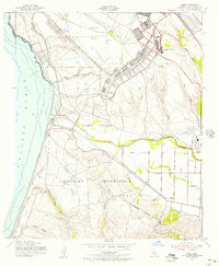
1947 Map of Surf
USGS Topo · Published 1956About this map
Camp Cooke Military Reservation dominates this coastal landscape during the mid-century era, showcasing an extensive network of roads and facilities established just after World War II. The map detail highlights the transformation of the central California coast into a massive training ground, featuring a Firing Range, specialized Barracks, and the sprawling infrastructure of Camp Cooke. Amidst this military presence, the historic Mission La Purisima stands as a landmark of the region's deeper past, situated near the banks of the Santa Ynez River.
Find a feature on this map
26 named features on this map. Tap any name to fly to it.
Don’t see what you’re looking for? This feature index may not catch every label — zoom into the map to look around manually.
Map Details
Editions of this 1947 Surf Map
2 editions found

Other maps of this area

1905 · Guadalupe
USGS Topo · 1:125,000

1905 · Lompoc
USGS Topo · 1:125,000

1942 · Point Arguello
USGS Topo · 1:62,500

1942 · Guadalupe
USGS Topo · 1:125,000

1942 · Lompoc
USGS Topo · 1:125,000

1942 · Lompoc
USGS Topo · 1:62,500

1942 · Santa Maria
USGS Topo · 1:62,500

1942 · Point Sal
USGS Topo · 1:62,500

1943 · Lompoc
USGS Topo · 1:125,000

1947 · Lompoc
USGS Topo · 1:24,000