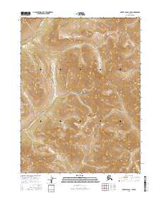
2016 Map of Survey Pass B-1 NW
USGS Topo · Published 2016About this map
Gates of the Arctic National Park dominates this landscape in the Brooks Range, where the terrain is defined by extreme relief and glacial drainage patterns. The Nahtuk River flows through the northern reaches of this quadrangle, carving a path through high-altitude ridges. To the west, the headwaters of Millichetah Creek begin their descent through steep valleys, while Tobuk Creek drains the southern portion of the survey. The mapping focuses on the preservation of these interior wilderness watersheds, showing the raw topographic contours of the Arctic divide. This 2016 survey provides a precise accounting of the hydrological network that sustains the ecosystems within the park boundaries, far removed from modern settlement.
Find a feature on this map
8 named features on this map. Tap any name to fly to it.
Don’t see what you’re looking for? This feature index may not catch every label — zoom into the map to look around manually.
Map Details
Editions of this 2016 Survey Pass B-1 NW Map
This is the sole edition of this map. No revisions or reprints were ever made.
Other maps of this area

1951 · Survey Pass
USGS Topo · 1:250,000

1956 · Survey Pass
USGS Topo · 1:250,000

1964 · Survey Pass
USGS Topo · 1:250,000

1966 · Survey Pass
USGS Topo · 1:250,000
1986 · Survey Pass C-2
USGS Topo · 1:63,360
1986 · Survey Pass C-1
USGS Topo · 1:63,360
1986 · Survey Pass B-2
USGS Topo · 1:63,360
1986 · Survey Pass B-1
USGS Topo · 1:63,360
2016 · Survey Pass C-2 SE
USGS Topo · 1:25,000
2016 · Survey Pass C-1 SW
USGS Topo · 1:25,000