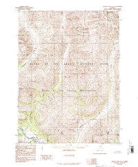
1986 Map of Survey Pass C-2
USGS Topo · Published 1986About this map
Gates of the Arctic National Park and the contiguous Gates of the Arctic Wilderness dominate this northern landscape, which was formally established just years prior to this publication via the Alaska National Interest Lands Conservation Act. The river systems define the geography of this roadless region, led by the wide channel of the Alatna River in the southwest corner. Tributaries like the Kutuk River and Pingaluk River flow through the interior, while Arrigetch Creek drains the southern reaches. In the north, Dallmaloak Mountain stands as a primary landmark near Dallmaloak Creek. This 1986 edition reflects a period of transition for Alaska's interior, moving from unassigned public lands to managed federal conservation units while remaining entirely devoid of permanent infrastructure or roads.
Find a feature on this map
16 named features on this map. Tap any name to fly to it.
Don’t see what you’re looking for? This feature index may not catch every label — zoom into the map to look around manually.
Map Details
Editions of this 1986 Survey Pass C-2 Map
This is the sole edition of this map. No revisions or reprints were ever made.
Other maps of this area

1951 · Survey Pass
USGS Topo · 1:250,000

1956 · Survey Pass
USGS Topo · 1:250,000

1964 · Survey Pass
USGS Topo · 1:250,000

1966 · Survey Pass
USGS Topo · 1:250,000
1986 · Survey Pass D-1
USGS Topo · 1:63,360
1986 · Survey Pass C-1
USGS Topo · 1:63,360
1986 · Survey Pass C-3
USGS Topo · 1:63,360
1986 · Survey Pass B-2
USGS Topo · 1:63,360
1986 · Survey Pass B-1
USGS Topo · 1:63,360
1986 · Survey Pass D-2
USGS Topo · 1:63,360