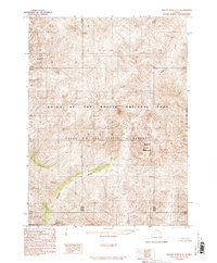
1986 Map of Survey Pass C-1
USGS Topo · Published 1986About this map
Gates Of The Arctic National Park and the adjacent Gates Of The Arctic Wilderness define this remote expanse of the Brooks Range as it was documented in the mid-1980s. The landscape is characterized by its high-latitude drainage systems, most notably the Pingaluk River in the northwest and the winding course of the Nahtuk River which cuts through the southern half of the quadrangle. Standing as a prominent topographical landmark, Nahtuk Mountain rises above the surrounding river valleys. This provisional survey, compiled from 1973 aerial photography, reveals a roadless interior where terrain is marked only by natural watercourses like Dawn Creek and the administrative line of the East Boundary Kateel River Meridian. The map captures a moment of preservation, focusing on the preservation of these lands within the national park system shortly after their formal designation.
Find a feature on this map
7 named features on this map. Tap any name to fly to it.
Don’t see what you’re looking for? This feature index may not catch every label — zoom into the map to look around manually.
Map Details
Editions of this 1986 Survey Pass C-1 Map
This is the sole edition of this map. No revisions or reprints were ever made.
Other maps of this area

1951 · Survey Pass
USGS Topo · 1:250,000

1951 · Wiseman
USGS Topo · 1:250,000

1956 · Wiseman
USGS Topo · 1:250,000

1956 · Survey Pass
USGS Topo · 1:250,000

1964 · Survey Pass
USGS Topo · 1:250,000

1964 · Wiseman
USGS Topo · 1:250,000

1966 · Survey Pass
USGS Topo · 1:250,000
1986 · Wiseman C-6
USGS Topo · 1:63,360
1986 · Survey Pass D-1
USGS Topo · 1:63,360
1986 · Survey Pass C-2
USGS Topo · 1:63,360