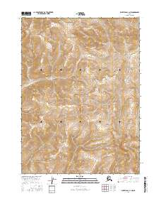
2016 Map of Survey Pass C-1 NW
USGS Topo · Published 2016About this map
Gates of the Arctic National Park encompasses the majority of this Alaskan wilderness, defined by high-altitude terrain and the path of the Pingaluk River. In this 2016 survey, the landscape is almost entirely undeveloped, with the topographic contours tracing a dense network of ridges and glacial valleys. The Pingaluk River flows southward through the western portion of the quadrangle, serving as the primary drainage for the surrounding peaks. This map provides a technical view of the northern interior before modern infrastructure reached these latitudes, preserving the primitive character of the Brooks Range. Researchers and conservationists can trace the specific township boundaries, including t27n r24e and t26n r24e, which overlay this protected expanse.
Find a feature on this map
6 named features on this map. Tap any name to fly to it.
Don’t see what you’re looking for? This feature index may not catch every label — zoom into the map to look around manually.
Map Details
Editions of this 2016 Survey Pass C-1 NW Map
This is the sole edition of this map. No revisions or reprints were ever made.
Other maps of this area

1951 · Survey Pass
USGS Topo · 1:250,000

1956 · Survey Pass
USGS Topo · 1:250,000

1964 · Survey Pass
USGS Topo · 1:250,000

1966 · Survey Pass
USGS Topo · 1:250,000
1986 · Survey Pass D-1
USGS Topo · 1:63,360
1986 · Survey Pass C-2
USGS Topo · 1:63,360
1986 · Survey Pass C-1
USGS Topo · 1:63,360
1986 · Survey Pass D-2
USGS Topo · 1:63,360
2016 · Survey Pass D-1 SW
USGS Topo · 1:25,000
2016 · Survey Pass C-2 SE
USGS Topo · 1:25,000