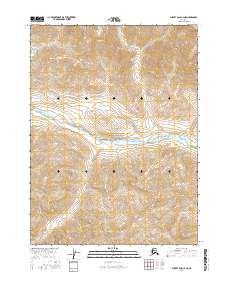
2016 Map of Survey Pass C-4 NE
USGS Topo · Published 2016About this map
Gates of the Arctic National Park encompasses the heart of this landscape, where the Alatna River snakes through the central valley. The river serves as the primary drainage for the surrounding terrain, fed by smaller tributaries such as Gull Cr to the south and Rain Cr entering from the east. The map detail reflects the protected status of the Brooks Range wilderness in the mid-2010s, focusing on the natural hydrography and elevation contours rather than human-made infrastructure. The lack of roads or settlements within the t27n r18e and t26n r19e township grids underscores the preserved, roadless character of this interior Alaskan territory.
Find a feature on this map
8 named features on this map. Tap any name to fly to it.
Don’t see what you’re looking for? This feature index may not catch every label — zoom into the map to look around manually.
Map Details
Editions of this 2016 Survey Pass C-4 NE Map
This is the sole edition of this map. No revisions or reprints were ever made.
Other maps of this area

1951 · Survey Pass
USGS Topo · 1:250,000

1956 · Survey Pass
USGS Topo · 1:250,000

1964 · Survey Pass
USGS Topo · 1:250,000

1966 · Survey Pass
USGS Topo · 1:250,000
1986 · Survey Pass C-3
USGS Topo · 1:63,360
1986 · Survey Pass D-4
USGS Topo · 1:63,360
1986 · Survey Pass C-4
USGS Topo · 1:63,360
1986 · Survey Pass D-3
USGS Topo · 1:63,360
2016 · Survey Pass C-4 SW
USGS Topo · 1:25,000
2016 · Survey Pass C-3 SW
USGS Topo · 1:25,000