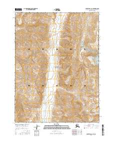
2016 Map of Survey Pass C-6 SE
USGS Topo · Published 2016About this map
Gates of the Arctic National Park dominates this remote landscape within the Northwest Arctic Borough. The drainage patterns of the Kugrak River flow northward through the center of the sheet, carving a wide valley between high topographic ridges. The terrain is marked by significant elevation changes, culminating in peaks like Oyukak Mtn in the northeast. Several smaller tributaries, including Oyukak Cr and Arch Cr, feed into the larger river systems, illustrating the complex hydrology of this subarctic wilderness. The map details the legal boundaries of Townships 24 through 26 North and Ranges 14 through 15 East, providing a precise grid for an area devoid of permanent human settlements or infrastructure. This data is essential for understanding the natural geography and protected status of the Brooks Range region during the early twenty-first century.
Find a feature on this map
11 named features on this map. Tap any name to fly to it.
Don’t see what you’re looking for? This feature index may not catch every label — zoom into the map to look around manually.
Map Details
Editions of this 2016 Survey Pass C-6 SE Map
This is the sole edition of this map. No revisions or reprints were ever made.
Other maps of this area

1951 · Survey Pass
USGS Topo · 1:250,000

1956 · Survey Pass
USGS Topo · 1:250,000

1964 · Survey Pass
USGS Topo · 1:250,000

1966 · Survey Pass
USGS Topo · 1:250,000
1990 · Survey Pass B-5
USGS Topo · 1:63,360
1990 · Survey Pass C-6
USGS Topo · 1:63,360
1990 · Survey Pass B-6
USGS Topo · 1:63,360
1990 · Survey Pass C-5
USGS Topo · 1:63,360
2016 · Survey Pass B-5 NW
USGS Topo · 1:25,000
2016 · Survey Pass C-6 NE
USGS Topo · 1:25,000