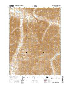
2016 Map of Survey Pass D-2 SW
USGS Topo · Published 2016About this map
Gates of the Arctic National Park encompasses the entire landscape of this 2016 survey, representing one of the most preserved wilderness environments in the American Arctic. The terrain is defined by the convergence of several significant glacial drainages, most notably the Unakserak River flowing south through the center of the sheet and the Kutuk River winding through the northern and eastern reaches. These watercourses serve as natural corridors through the high country, linked by landmarks like Kutuk Pass in the northwest corner. Smaller tributaries such as Survey Cr and Passless Cr illustrate the complex hydrography of the Brooks Range, where the absence of roads or established trails highlights the remote and undeveloped nature of this protected interior Alaska wilderness.
Find a feature on this map
12 named features on this map. Tap any name to fly to it.
Don’t see what you’re looking for? This feature index may not catch every label — zoom into the map to look around manually.
Map Details
Editions of this 2016 Survey Pass D-2 SW Map
This is the sole edition of this map. No revisions or reprints were ever made.
Other maps of this area

1951 · Survey Pass
USGS Topo · 1:250,000

1956 · Survey Pass
USGS Topo · 1:250,000

1964 · Survey Pass
USGS Topo · 1:250,000

1966 · Survey Pass
USGS Topo · 1:250,000
1986 · Survey Pass C-2
USGS Topo · 1:63,360
1986 · Survey Pass C-3
USGS Topo · 1:63,360
1986 · Survey Pass D-2
USGS Topo · 1:63,360
1986 · Survey Pass D-3
USGS Topo · 1:63,360
2016 · Survey Pass C-2 NW
USGS Topo · 1:25,000
2016 · Survey Pass C-2 NE
USGS Topo · 1:25,000