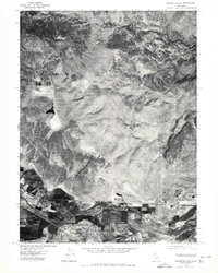
1975 Map of Susanville NE
USGS Topo · Published 1980About this map
Johnstonville and the surrounding agricultural valley of the Susan River are clearly visible in this mid-1970s orthophotoquad. This specialized imagery provides a photographic view of the landscape's development, contrasting the cultivated fields and irrigation patterns of the valley floor with the undeveloped terrain of Antelope Mtn. To the north, the winding course of Willow Creek cuts through the high ground, while the settlement of Leavitt sits positioned near the eastern edge of the survey area. The map's photographic nature captures the exact footprint of farmsteads and rural road networks as they existed in 1975, offering researchers a literal view of the transition from the river bottom to the arid uplands of northeastern California.
Find a feature on this map
5 named features on this map. Tap any name to fly to it.
Don’t see what you’re looking for? This feature index may not catch every label — zoom into the map to look around manually.
Map Details
Editions of this 1975 Susanville NE Map
2 editions found
Other maps of this area

1886 · Honey Lake
USGS Topo · 1:250,000

1891 · Honey Lake
USGS Topo · 1:250,000

1893 · Honey Lake
USGS Topo · 1:250,000

1954 · Susanville
USGS Topo · 1:62,500

1954 · Litchfield
USGS Topo · 1:62,500

1954 · Karlo
USGS Topo · 1:62,500

1954 · Fredonyer Peak
USGS Topo · 1:62,500

1955 · Westwood
USGS Topo · 1:250,000

1958 · Westwood
USGS Topo · 1:250,000

1959 · Westwood
USGS Topo · 1:250,000