1975 Map of Susanville NE
USGS Topo · Published 1979About this map
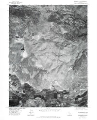
The Susan River winds through the southern reaches of this landscape, defining the agricultural and settlement patterns of Lassen County in the mid-1970s. The community of Johnstonville sits at a critical junction in the river valley, showing the clustered development and farm grid that characterize the region's lowlands. To the north, the terrain transitions sharply into the uplands of Antelope Mtn, where the high-altitude topography is dissected by drainage systems like Willow Creek. This orthophotoquad provides a literal photographic record of the land use, contrasting the irrigated fields near Leavitt against the arid, brush-covered slopes of the surrounding peaks. It captures the intersection of water-dependent valley life and the open range of the high desert before further modern development altered these rural corridors.
Find a feature on this map
5 named features on this map. Tap any name to fly to it.
Don’t see what you’re looking for? This feature index may not catch every label — zoom into the map to look around manually.
Map Details
Editions of this 1975 Susanville NE Map
2 editions found
Historical Maps of Susanville Through Time
410 maps found

1886 Honey Lake
Lassen County, CA

1891 Honey Lake
Lassen County, CA

1893 Honey Lake
Lassen County, CA

1939 Halls Flat
Lassen County, CA

1954 Fredonyer Peak
Lassen County, CA

1954 Grasshopper Valley
Lassen County, CA

1954 Karlo
Lassen County, CA

1954 Observation Peak
Lassen County, CA

1954 Ravendale
Lassen County, CA

1954 Shinn Mountain
Lassen County, CA

1954 Wendel
Lassen County, CA

1956 Antelope Mtn
Lassen County, CA

1956 Harvey Mtn
Lassen County, CA

1956 Hayden Hill
Lassen County, CA

1962 Boot Lake
Lassen County, CA

1962 Cold Spring Mtn
Lassen County, CA

1962 Little Hat Mtn
Lassen County, CA

1972 Diamond Mtn
Lassen County, CA

1972 Standish
Lassen County, CA

1975 Beckwourth Pass
Lassen County, CA

1975 Prospect Peak SE
Lassen County, CA

1975 Susanville NE
Lassen County, CA

1975 Susanville NW
Lassen County, CA

1977 Constantia
Lassen County, CA

1978 Mc Kesick Peak
Lassen County, CA

1978 Stony Ridge
Lassen County, CA

1979 Swain Mountain
Lassen County, CA

1980 Fredonyer Pass
Lassen County, CA

1980 Pegleg Mountain
Lassen County, CA

1980 Roop Mountain
Lassen County, CA

1980 Westwood East
Lassen County, CA

1983 Antelope Mtn
Lassen County, CA

1983 Bogard Buttes
Lassen County, CA

1983 Bullard Lake
Lassen County, CA

1983 Champs Flat
Lassen County, CA

1983 Corders Reservoir
Lassen County, CA

1983 Dixie Peak
Lassen County, CA

1983 Harvey Mountain
Lassen County, CA

1983 Pikes Point
Lassen County, CA

1983 Pine Creek Valley
Lassen County, CA

1983 Poison Lake
Lassen County, CA

1983 Said Valley
Lassen County, CA

1983 Sheepshead
Lassen County, CA

1983 Silva Flat Reservoir
Lassen County, CA

1983 Spalding Tract
Lassen County, CA

1983 Straylor Lake
Lassen County, CA

1985 Prospect Peak
Lassen County, CA

1985 Swains Hole
Lassen County, CA

1988 Bull Flat
Lassen County, CA

1988 Calneva Lake
Lassen County, CA

1988 Little Mud Flat
Lassen County, CA

1988 Shaffer Mtn
Lassen County, CA

1988 Spencer Creek
Lassen County, CA

1988 Wendel Hot Springs
Lassen County, CA

1988 Wendel
Lassen County, CA

1989 Al Shinn Canyon
Lassen County, CA

1989 Anderson Mountain
Lassen County, CA

1989 Buckhorn Canyon
Lassen County, CA

1989 Buckhorn Lake
Lassen County, CA

1989 Cherry Mountain
Lassen County, CA

1989 Cleghorn Flat
Lassen County, CA

1989 Dodge Reservoir
Lassen County, CA

1989 Five Springs
Lassen County, CA

1989 Fredonyer Peak
Lassen County, CA

1989 Gallatin Peak
Lassen County, CA

1989 Grasshopper Valley
Lassen County, CA

1989 Juniper Ridge
Lassen County, CA

1989 Karlo
Lassen County, CA

1989 McDonald Peak
Lassen County, CA

1989 Observation Peak
Lassen County, CA

1989 Petes Valley
Lassen County, CA

1989 Ravendale
Lassen County, CA

1989 Shinn Mountain
Lassen County, CA

1989 Snowstorm Mountain
Lassen County, CA

1989 Termo
Lassen County, CA

1989 Troxel Point
Lassen County, CA

1989 Tunnison Mountain
Lassen County, CA

1989 West of Snowstorm Mtn
Lassen County, CA

1989 Whitinger Mountain
Lassen County, CA

1990 Ash Valley
Lassen County, CA

1990 Coble Mountain
Lassen County, CA

1990 Hog Valley
Lassen County, CA

1990 Holbrook Canyon
Lassen County, CA

1990 Jellico
Lassen County, CA

1990 Lane Reservoir
Lassen County, CA

1990 Letterbox Hill
Lassen County, CA

1990 Pittville
Lassen County, CA

1992 Eagle Lake
Lassen County, CA

1993 Ash Valley
Lassen County, CA

1993 Boot Lake
Lassen County, CA

1993 Cold Spring Mtn
Lassen County, CA

1993 Dixie Peak
Lassen County, CA

1993 Hog Valley
Lassen County, CA

1993 Lane Reservoir
Lassen County, CA

1993 Letterbox Hill
Lassen County, CA

1993 Little Hat Mtn.
Lassen County, CA

1993 Said Valley
Lassen County, CA

1993 Silva Flat Reservoir
Lassen County, CA

1993 Whitinger Mountain
Lassen County, CA

1994 Beckwourth Pass
Lassen County, CA

1994 Constantia
Lassen County, CA

1994 Diamond Mountain
Lassen County, CA

1994 Mc Kesick Peak
Lassen County, CA

1994 Standish
Lassen County, CA

1994 Stony Ridge
Lassen County, CA

1995 Antelope Mountain
Lassen County, CA

1995 Bogard Buttes
Lassen County, CA

1995 Bullard Lake
Lassen County, CA

1995 Champs Flat
Lassen County, CA

1995 Coble Mountain
Lassen County, CA

1995 Corders Reservoir
Lassen County, CA

1995 Fredonyer Pass
Lassen County, CA

1995 Gallatin Peak
Lassen County, CA

1995 Harvey Mountain
Lassen County, CA

1995 Jellico
Lassen County, CA

1995 Pegleg Mountain
Lassen County, CA

1995 Pikes Point
Lassen County, CA

1995 Pine Creek Valley
Lassen County, CA

1995 Pittville
Lassen County, CA

1995 Poison Lake
Lassen County, CA

1995 Prospect Peak
Lassen County, CA

1995 Roop Mountain
Lassen County, CA

1995 Sheepshead
Lassen County, CA

1995 Spalding Tract
Lassen County, CA

1995 Straylor Lake
Lassen County, CA

1995 Swain Mountain
Lassen County, CA

1995 Swains Hole
Lassen County, CA

1995 Troxel Point
Lassen County, CA

1995 Westwood East
Lassen County, CA

2012 Al Shinn Canyon
Lassen County, CA

2012 Anderson Mountain
Lassen County, CA

2012 Antelope Mountain
Lassen County, CA

2012 Ash Valley
Lassen County, CA

2012 Beckwourth Pass
Lassen County, CA

2012 Bogard Buttes
Lassen County, CA

2012 Boot Lake
Lassen County, CA

2012 Buckhorn Canyon
Lassen County, CA

2012 Buckhorn Lake
Lassen County, CA

2012 Bullard Lake
Lassen County, CA

2012 Bull Flat
Lassen County, CA

2012 Calneva Lake
Lassen County, CA

2012 Champs Flat
Lassen County, CA

2012 Cherry Mountain
Lassen County, CA

2012 Cleghorn Flat
Lassen County, CA

2012 Coble Mountain
Lassen County, CA

2012 Cold Spring Mountain
Lassen County, CA

2012 Constantia
Lassen County, CA

2012 Corders Reservoir
Lassen County, CA

2012 Diamond Mountain
Lassen County, CA

2012 Dixie Peak
Lassen County, CA

2012 Dodge Reservoir
Lassen County, CA

2012 Five Springs
Lassen County, CA

2012 Fredonyer Pass
Lassen County, CA

2012 Fredonyer Peak
Lassen County, CA

2012 Gallatin Peak
Lassen County, CA

2012 Grasshopper Valley
Lassen County, CA

2012 Harvey Mountain
Lassen County, CA

2012 Hog Valley
Lassen County, CA

2012 Holbrook Canyon
Lassen County, CA

2012 Jellico
Lassen County, CA

2012 Juniper Ridge
Lassen County, CA

2012 Karlo
Lassen County, CA

2012 Lane Reservoir
Lassen County, CA

2012 Letterbox Hill
Lassen County, CA

2012 Little Hat Mountain
Lassen County, CA

2012 Little Mud Flat
Lassen County, CA

2012 McDonald Peak
Lassen County, CA

2012 McKesick Peak
Lassen County, CA

2012 Observation Peak
Lassen County, CA

2012 Pegleg Mountain
Lassen County, CA

2012 Petes Valley
Lassen County, CA

2012 Pikes Point
Lassen County, CA

2012 Pine Creek Valley
Lassen County, CA

2012 Pittville
Lassen County, CA

2012 Poison Lake
Lassen County, CA

2012 Prospect Peak
Lassen County, CA

2012 Ravendale
Lassen County, CA

2012 Roop Mountain
Lassen County, CA

2012 Said Valley
Lassen County, CA

2012 Shaffer Mountain
Lassen County, CA

2012 Sheepshead
Lassen County, CA

2012 Shinn Mountain
Lassen County, CA

2012 Silva Flat Reservoir
Lassen County, CA

2012 Snowstorm Mountain
Lassen County, CA

2012 Spalding Tract
Lassen County, CA

2012 Spencer Creek
Lassen County, CA

2012 Standish
Lassen County, CA

2012 Stony Ridge
Lassen County, CA

2012 Straylor Lake
Lassen County, CA

2012 Swain Mountain
Lassen County, CA

2012 Swains Hole
Lassen County, CA

2012 Termo
Lassen County, CA

2012 Troxel Point
Lassen County, CA

2012 Tunnison Mountain
Lassen County, CA

2012 Wendel Hot Springs
Lassen County, CA

2012 Wendel
Lassen County, CA

2012 West of Snowstorm Mountain
Lassen County, CA

2012 Westwood East
Lassen County, CA

2012 Whitinger Mountain
Lassen County, CA

2015 Al Shinn Canyon
Lassen County, CA

2015 Anderson Mountain
Lassen County, CA

2015 Antelope Mountain
Lassen County, CA

2015 Ash Valley
Lassen County, CA

2015 Beckwourth Pass
Lassen County, CA

2015 Bogard Buttes
Lassen County, CA

2015 Boot Lake
Lassen County, CA

2015 Buckhorn Canyon
Lassen County, CA

2015 Buckhorn Lake
Lassen County, CA

2015 Bullard Lake
Lassen County, CA

2015 Bull Flat
Lassen County, CA

2015 Calneva Lake
Lassen County, CA

2015 Champs Flat
Lassen County, CA

2015 Cherry Mountain
Lassen County, CA

2015 Cleghorn Flat
Lassen County, CA

2015 Coble Mountain
Lassen County, CA

2015 Cold Spring Mountain
Lassen County, CA

2015 Constantia
Lassen County, CA

2015 Corders Reservoir
Lassen County, CA

2015 Diamond Mountain
Lassen County, CA

2015 Dixie Peak
Lassen County, CA

2015 Dodge Reservoir
Lassen County, CA

2015 Five Springs
Lassen County, CA

2015 Fredonyer Pass
Lassen County, CA

2015 Fredonyer Peak
Lassen County, CA

2015 Gallatin Peak
Lassen County, CA

2015 Grasshopper Valley
Lassen County, CA

2015 Harvey Mountain
Lassen County, CA

2015 Hog Valley
Lassen County, CA

2015 Holbrook Canyon
Lassen County, CA

2015 Jellico
Lassen County, CA

2015 Juniper Ridge
Lassen County, CA

2015 Karlo
Lassen County, CA

2015 Lane Reservoir
Lassen County, CA

2015 Letterbox Hill
Lassen County, CA

2015 Little Hat Mountain
Lassen County, CA

2015 Little Mud Flat
Lassen County, CA

2015 McDonald Peak
Lassen County, CA

2015 McKesick Peak
Lassen County, CA

2015 Observation Peak
Lassen County, CA

2015 Pegleg Mountain
Lassen County, CA

2015 Petes Valley
Lassen County, CA

2015 Pikes Point
Lassen County, CA

2015 Pine Creek Valley
Lassen County, CA

2015 Pittville
Lassen County, CA

2015 Poison Lake
Lassen County, CA

2015 Prospect Peak
Lassen County, CA

2015 Ravendale
Lassen County, CA

2015 Roop Mountain
Lassen County, CA

2015 Said Valley
Lassen County, CA

2015 Shaffer Mountain
Lassen County, CA

2015 Sheepshead
Lassen County, CA

2015 Shinn Mountain
Lassen County, CA

2015 Silva Flat Reservoir
Lassen County, CA

2015 Snowstorm Mountain
Lassen County, CA

2015 Spalding Tract
Lassen County, CA

2015 Spencer Creek
Lassen County, CA

2015 Standish
Lassen County, CA

2015 Stony Ridge
Lassen County, CA

2015 Straylor Lake
Lassen County, CA

2015 Swain Mountain
Lassen County, CA

2015 Swains Hole
Lassen County, CA

2015 Termo
Lassen County, CA

2015 Troxel Point
Lassen County, CA

2015 Tunnison Mountain
Lassen County, CA

2015 Wendel Hot Springs
Lassen County, CA

2015 Wendel
Lassen County, CA

2015 West of Snowstorm Mountain
Lassen County, CA

2015 Westwood East
Lassen County, CA

2015 Whitinger Mountain
Lassen County, CA

2018 Al Shinn Canyon
Lassen County, CA

2018 Anderson Mountain
Lassen County, CA

2018 Antelope Mountain
Lassen County, CA

2018 Ash Valley
Lassen County, CA

2018 Beckwourth Pass
Lassen County, CA

2018 Bogard Buttes
Lassen County, CA

2018 Boot Lake
Lassen County, CA

2018 Buckhorn Canyon
Lassen County, CA

2018 Buckhorn Lake
Lassen County, CA

2018 Bullard Lake
Lassen County, CA

2018 Bull Flat
Lassen County, CA

2018 Calneva Lake
Lassen County, CA

2018 Champs Flat
Lassen County, CA

2018 Cherry Mountain
Lassen County, CA

2018 Cleghorn Flat
Lassen County, CA

2018 Coble Mountain
Lassen County, CA

2018 Cold Spring Mountain
Lassen County, CA

2018 Constantia
Lassen County, CA

2018 Corders Reservoir
Lassen County, CA

2018 Diamond Mountain
Lassen County, CA

2018 Dixie Peak
Lassen County, CA

2018 Dodge Reservoir
Lassen County, CA

2018 Five Springs
Lassen County, CA

2018 Fredonyer Pass
Lassen County, CA

2018 Fredonyer Peak
Lassen County, CA

2018 Gallatin Peak
Lassen County, CA

2018 Grasshopper Valley
Lassen County, CA

2018 Harvey Mountain
Lassen County, CA

2018 Hog Valley
Lassen County, CA

2018 Holbrook Canyon
Lassen County, CA

2018 Jellico
Lassen County, CA

2018 Juniper Ridge
Lassen County, CA

2018 Karlo
Lassen County, CA

2018 Lane Reservoir
Lassen County, CA

2018 Letterbox Hill
Lassen County, CA

2018 Little Hat Mountain
Lassen County, CA

2018 Little Mud Flat
Lassen County, CA

2018 McDonald Peak
Lassen County, CA

2018 McKesick Peak
Lassen County, CA

2018 Observation Peak
Lassen County, CA

2018 Pegleg Mountain
Lassen County, CA

2018 Petes Valley
Lassen County, CA

2018 Pikes Point
Lassen County, CA

2018 Pine Creek Valley
Lassen County, CA

2018 Pittville
Lassen County, CA

2018 Poison Lake
Lassen County, CA

2018 Prospect Peak
Lassen County, CA

2018 Ravendale
Lassen County, CA

2018 Roop Mountain
Lassen County, CA

2018 Said Valley
Lassen County, CA

2018 Shaffer Mountain
Lassen County, CA

2018 Sheepshead
Lassen County, CA

2018 Shinn Mountain
Lassen County, CA

2018 Silva Flat Reservoir
Lassen County, CA

2018 Snowstorm Mountain
Lassen County, CA

2018 Spalding Tract
Lassen County, CA

2018 Spencer Creek
Lassen County, CA

2018 Standish
Lassen County, CA

2018 Stony Ridge
Lassen County, CA

2018 Straylor Lake
Lassen County, CA

2018 Swain Mountain
Lassen County, CA

2018 Swains Hole
Lassen County, CA

2018 Termo
Lassen County, CA

2018 Troxel Point
Lassen County, CA

2018 Tunnison Mountain
Lassen County, CA

2018 Wendel Hot Springs
Lassen County, CA

2018 Wendel
Lassen County, CA

2018 West of Snowstorm Mountain
Lassen County, CA

2018 Westwood East
Lassen County, CA

2018 Whitinger Mountain
Lassen County, CA

2021 Al Shinn Canyon
Lassen County, CA

2021 Anderson Mountain
Lassen County, CA

2021 Beckwourth Pass
Lassen County, CA

2021 Boot Lake
Lassen County, CA

2021 Buckhorn Canyon
Lassen County, CA

2021 Buckhorn Lake
Lassen County, CA

2021 Bullard Lake
Lassen County, CA

2021 Bull Flat
Lassen County, CA

2021 Calneva Lake
Lassen County, CA

2021 Champs Flat
Lassen County, CA

2021 Cherry Mountain
Lassen County, CA

2021 Cleghorn Flat
Lassen County, CA

2021 Coble Mountain
Lassen County, CA

2021 Constantia
Lassen County, CA

2021 Corders Reservoir
Lassen County, CA

2021 Diamond Mountain
Lassen County, CA

2021 Dixie Peak
Lassen County, CA

2021 Dodge Reservoir
Lassen County, CA

2021 Five Springs
Lassen County, CA

2021 Fredonyer Pass
Lassen County, CA

2021 Fredonyer Peak
Lassen County, CA

2021 Gallatin Peak
Lassen County, CA

2021 Grasshopper Valley
Lassen County, CA

2021 Harvey Mountain
Lassen County, CA

2021 Hog Valley
Lassen County, CA

2021 Holbrook Canyon
Lassen County, CA

2021 Jellico
Lassen County, CA

2021 Juniper Ridge
Lassen County, CA

2021 Karlo
Lassen County, CA

2021 Lane Reservoir
Lassen County, CA

2021 Letterbox Hill
Lassen County, CA

2021 Little Hat Mountain
Lassen County, CA

2021 Little Mud Flat
Lassen County, CA

2021 McDonald Peak
Lassen County, CA

2021 McKesick Peak
Lassen County, CA

2021 Observation Peak
Lassen County, CA

2021 Pegleg Mountain
Lassen County, CA

2021 Petes Valley
Lassen County, CA

2021 Pikes Point
Lassen County, CA

2021 Pine Creek Valley
Lassen County, CA

2021 Pittville
Lassen County, CA

2021 Poison Lake
Lassen County, CA

2021 Prospect Peak
Lassen County, CA

2021 Ravendale
Lassen County, CA

2021 Said Valley
Lassen County, CA

2021 Shaffer Mountain
Lassen County, CA

2021 Sheepshead
Lassen County, CA

2021 Shinn Mountain
Lassen County, CA

2021 Silva Flat Reservoir
Lassen County, CA

2021 Snowstorm Mountain
Lassen County, CA

2021 Spalding Tract
Lassen County, CA

2021 Spencer Creek
Lassen County, CA

2021 Stony Ridge
Lassen County, CA

2021 Straylor Lake
Lassen County, CA

2021 Swain Mountain
Lassen County, CA

2021 Termo
Lassen County, CA

2021 Tunnison Mountain
Lassen County, CA

2021 Wendel Hot Springs
Lassen County, CA

2021 Wendel
Lassen County, CA

2021 West of Snowstorm Mountain
Lassen County, CA

2021 Whitinger Mountain
Lassen County, CA

2022 Antelope Mountain
Lassen County, CA

2022 Ash Valley
Lassen County, CA

2022 Bogard Buttes
Lassen County, CA

2022 Cold Spring Mountain
Lassen County, CA

2022 Roop Mountain
Lassen County, CA

2022 Standish
Lassen County, CA

2022 Swains Hole
Lassen County, CA

2022 Troxel Point
Lassen County, CA

2022 Westwood East
Lassen County, CA

2023 Champs Flat
Lassen County, CA