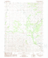
1989 Map of Snowstorm Mountain
USGS Topo · Published 1989About this map
Snowstorm Mountain dominates this portion of Lassen County, serving as the high point of a landscape defined by deep drainages and vital water sources. In this late twentieth-century survey, the prominence of springs suggests their critical role for both local wildlife and land management in this arid high-country environment. Named features like Spanish Springs, Rye Patch Spring, and Tule Patch Spring are scattered across the terrain, indicating a network of reliable water points. The map reveals limited human infrastructure, such as the Ramhorn Campground and a single Heliport, reflecting the area's primary use for recreation and resource management. Deep canyons, including Vincent Canyon and Nye Canyon, cut through the slopes, while Secret Creek and Snowstorm Creek provide the primary drainage system for the massif.
Find a feature on this map
19 named features on this map. Tap any name to fly to it.
Don’t see what you’re looking for? This feature index may not catch every label — zoom into the map to look around manually.
Map Details
Editions of this 1989 Snowstorm Mountain Map
2 editions found
Other maps of this area

1886 · Honey Lake
USGS Topo · 1:250,000

1891 · Honey Lake
USGS Topo · 1:250,000

1893 · Honey Lake
USGS Topo · 1:250,000

1954 · Observation Peak
USGS Topo · 1:62,500

1954 · Karlo
USGS Topo · 1:62,500

1954 · Ravendale
USGS Topo · 1:62,500

1954 · Shinn Mountain
USGS Topo · 1:62,500

1955 · Westwood
USGS Topo · 1:250,000

1958 · Westwood
USGS Topo · 1:250,000

1959 · Westwood
USGS Topo · 1:250,000