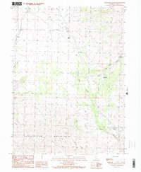
1989 Map of Snowstorm Mountain
USGS Topo · Published 1989About this map
Spanish Springs serves as a key landmark in this high-altitude landscape of Lassen County, where water sources dictate the movement of people and livestock. The map traces a complex network of seasonal drainages and springs, including Rye Patch Spring and Tule Patch Spring, which support the dry surroundings of Snowstorm Mountain. Primitive 4WD tracks provide the primary access through deep cuts like Vincent Canyon and Nye Canyon, highlighting the era's reliance on rugged transportation for land management and recreational use. Evidence of local industry and infrastructure appears at the Gravel Pit and a remote Heliport, while the Ramhorn Campground marks a point of human interface with the high-desert terrain. The survey captures a moment in the late 20th century when these remote California uplands remained largely defined by their natural topography and sparse, functional improvements.
Find a feature on this map
22 named features on this map. Tap any name to fly to it.
Don’t see what you’re looking for? This feature index may not catch every label — zoom into the map to look around manually.
Map Details
Editions of this 1989 Snowstorm Mountain Map
2 editions found
Other maps of this area

1886 · Honey Lake
USGS Topo · 1:250,000

1891 · Honey Lake
USGS Topo · 1:250,000

1893 · Honey Lake
USGS Topo · 1:250,000

1954 · Observation Peak
USGS Topo · 1:62,500

1954 · Karlo
USGS Topo · 1:62,500

1954 · Ravendale
USGS Topo · 1:62,500

1954 · Shinn Mountain
USGS Topo · 1:62,500

1955 · Westwood
USGS Topo · 1:250,000

1958 · Westwood
USGS Topo · 1:250,000

1959 · Westwood
USGS Topo · 1:250,000