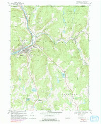
1968 Map of Susquehanna
USGS Topo · Published 1991About this map
The Susquehanna River winds sharply through this northern Pennsylvania borderland, anchoring the sister boroughs of Susquehanna and Oakland at a historic rail and industrial nexus. The landscape is defined by the steep grades of Oak Hill and Taylor Hill, where the tracks of Conrail and the Delaware and Hudson railroad follow the river's bend and the course of Starrucca Creek. This 1960s-era survey reveals a community well-served by civic infrastructure, including the Susquehanna Consolidated Sch, Barnes Hosp, and multiple religious sites like St Johns Ch.
Find a feature on this map
56 named features on this map. Tap any name to fly to it.
Don’t see what you’re looking for? This feature index may not catch every label — zoom into the map to look around manually.
Map Details
Editions of this 1968 Susquehanna Map
4 editions found
Other maps of this area

1905 · Nineveh
USGS Topo · 1:62,500

1924 · Starrucca
USGS Topo · 1:48,000

1924 · Deposit
USGS Topo · 1:62,500

1926 · Deposit
USGS Topo · 1:62,500

1926 · Starrucca
USGS Topo · 1:62,500

1930 · Starrucca
USGS Topo · 1:48,000

1932 · Susquehanna
USGS Topo · 1:62,500

1933 · Starrucca
USGS Topo · 1:62,500

1935 · Susquehanna
USGS Topo · 1:62,500

1943 · Honesdale
USGS Topo · 1:125,000