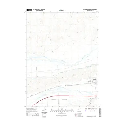
2014 Map of Sutherland Reservoir NW
USGS Topo · Published 2014About this map
Sutherland sits between two major river systems in this Lincoln County landscape, showing the complex water management required for High Plains agriculture. The North Platte River and South Platte River both cross the terrain, accompanied by an intricate network of irrigation infrastructure. The Keith Lincoln Canal and Paxton Hershey Canal parallel the rivers, demonstrating how the region's economy is tied to these artificial waterways. South of the town center, the Sutherland Cem is located near Sutherland Cemetery Rd, while Bull Ditch and East Clear Cr contribute to the local drainage system. This survey illustrates the dense grid of local roads, such as N King Rd and S Seifer Rd, which organize the rural sections surrounding the community.
Find a feature on this map
28 named features on this map. Tap any name to fly to it.
Don’t see what you’re looking for? This feature index may not catch every label — zoom into the map to look around manually.
Map Details
Editions of this 2014 Sutherland Reservoir NW Map
This is the sole edition of this map. No revisions or reprints were ever made.
Other maps of this area

1898 · Paxton
USGS Topo · 1:125,000

1901 · Paxton
USGS Topo · 1:125,000

1954 · North Platte
USGS Topo · 1:250,000

1956 · North Platte
USGS Topo · 1:250,000

1957 · North Platte
USGS Topo · 1:250,000

1967 · North Platte
USGS Topo · 1:250,000

1971 · Sutherland Reservoir West
USGS Topo · 1:24,000
1971 · Paxton South
USGS Topo · 1:24,000
1971 · Paxton North
USGS Topo · 1:24,000
1971 · Hershey West
USGS Topo · 1:24,000