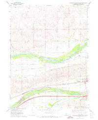
1971 Map of Sutherland Reservoir NW
USGS Topo · Published 1974About this map
The confluence of the North Platte River and South Platte River valley defines this Lincoln County landscape during the early 1970s. The village of Sutherland serves as the local hub, situated between the river systems and the southern Keith Lincoln County Canal. Transportation and irrigation infrastructure dominate the area, from the Union Pacific railroad tracks to the Trego Landing Strip and the complex network of waterways including the Paxton Hershey Canal. Water management is central to the valley's character, evidenced by the Diversion Dam and several gaging stations. Further south, the Sutherland Reservoir Park and Sutherland Cemetery provide fixed points for local genealogy and land-use studies, while nearby Gravel Pits indicate the era's local extractive industry.
Find a feature on this map
21 named features on this map. Tap any name to fly to it.
Don’t see what you’re looking for? This feature index may not catch every label — zoom into the map to look around manually.
Map Details
Editions of this 1971 Sutherland Reservoir NW Map
This is the sole edition of this map. No revisions or reprints were ever made.
Other maps of this area

1898 · Paxton
USGS Topo · 1:125,000

1901 · Paxton
USGS Topo · 1:125,000

1954 · North Platte
USGS Topo · 1:250,000

1956 · North Platte
USGS Topo · 1:250,000

1957 · North Platte
USGS Topo · 1:250,000

1967 · North Platte
USGS Topo · 1:250,000

1971 · Sutherland Reservoir West
USGS Topo · 1:24,000
1971 · Paxton South
USGS Topo · 1:24,000
1971 · Paxton North
USGS Topo · 1:24,000
1971 · Hershey West
USGS Topo · 1:24,000