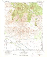
1954 Map of Sutter Buttes
USGS Topo · Published 1974About this map
Sutter Buttes rise dramatically from the valley floor in this mid-century topographic record, showcasing the distinctive volcanic peaks of North Butte, West Butte, and South Butte. The landscape transitions from these prominent heights into the managed water systems of the Sacramento Valley, where the Sutter Bypass and Butte Slough define the hydrological character of the region. Local life is anchored by the community of Sutter in the east, while smaller clusters like Tarke and Lira sit near the critical levee systems. This era captures the area's agricultural reliance on water management, evidenced by numerous Gas Wells and the Wadsworth Canal. Genealogists may find value in locating the Stohlman Cem and the Slough Sch, which served the rural population living along the transition from the peaks of Old Craggy and Twin Peaks to the valley farmlands below.
Find a feature on this map
41 named features on this map. Tap any name to fly to it.
Don’t see what you’re looking for? This feature index may not catch every label — zoom into the map to look around manually.
Map Details
Editions of this 1954 Sutter Buttes Map
4 editions found
Other maps of this area

1888 · Marysville
USGS Topo · 1:125,000

1891 · Marysville
USGS Topo · 1:125,000

1894 · Marysville
USGS Topo · 1:125,000

1895 · Marysville
USGS Topo · 1:125,000

1911 · Sutter
USGS Topo · 1:31,680

1911 · Sanborn Slough
USGS Topo · 1:31,680

1911 · Grimes
USGS Topo · 1:31,680

1911 · Gilsizer Slough
USGS Topo · 1:31,680

1912 · Marysville Buttes
USGS Topo · 1:31,680

1912 · Pennington
USGS Topo · 1:31,680