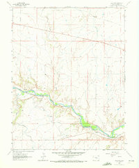
1963 Map of Swallows
USGS Topo · Published 1972About this map
The Arkansas River serves as the central artery of this landscape, carving a valley that dictated the placement of early infrastructure and small settlements like Swallows and Livesey. The corridor is defined by complex water engineering, including the Arkansas Valley Conduit, Minnequa Canal, and Teller Ditch, which redirect water through the arid terrain. Transportation history is deeply etched into the topography, with the Denver and Rio Grande Western line hugging the river's northern bank while an Old Railroad Grade traverses the northern uplands. Numerous drainages such as Turkey Creek, Rush Creek, and Peck Creek feed into the main river channel from the surrounding hills. This survey documents the intersection of natural river geography and the industrial efforts to harness water and rail for the region's development.
Find a feature on this map
15 named features on this map. Tap any name to fly to it.
Don’t see what you’re looking for? This feature index may not catch every label — zoom into the map to look around manually.
Map Details
Editions of this 1963 Swallows Map
6 editions found
Other maps of this area

1891 · Pueblo
USGS Topo · 1:125,000

1894 · Pueblo
USGS Topo · 1:125,000

1896 · Pueblo
USGS Topo · 1:125,000

1897 · Pueblo
USGS Topo · 1:125,000

1954 · Pueblo
USGS Topo · 1:250,000

1957 · Pueblo
USGS Topo · 1:250,000

1958 · Pueblo
USGS Topo · 1:250,000
1961 · Steele Hollow
USGS Topo · 1:24,000

1961 · Northwest Pueblo
USGS Topo · 1:24,000

1961 · Southwest Pueblo
USGS Topo · 1:24,000