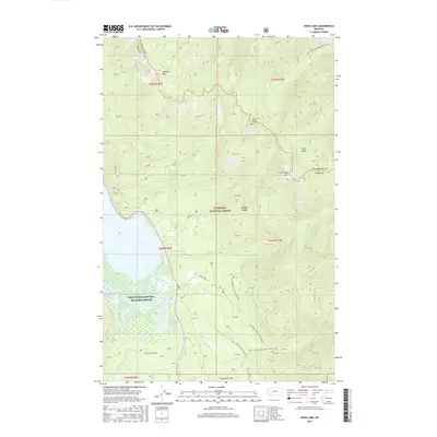
2017 Map of Swan Lake
USGS Topo · Published 2017About this map
Swan Lake serves as the focal point for this 2017 survey of the Lake and Flathead County border, where the mountains of the Swan Range meet the riparian lowlands. The southern end of the lake transitions into the Swan River National Wildlife Refuge, a complex of wetlands fed by the Swan River and Spring Cr. High-elevation landmarks such as Hall Peak, Con Kelley Mtn, and Sixmile Mtn define the surrounding Flathead National Forest, providing a clear view of the drainage patterns for Bond Cr and Johnson Cr. The map details a network of forest access routes, including Porcupine Creek Rd and the Bond Creek Trl, which provide historical context for the area's land management and recreational development. These trails and roads trace the steep topography between the valley floor and the high peaks of the northern Rockies.
Find a feature on this map
44 named features on this map. Tap any name to fly to it.
Don’t see what you’re looking for? This feature index may not catch every label — zoom into the map to look around manually.
Map Details
Editions of this 2017 Swan Lake Map
This is the sole edition of this map. No revisions or reprints were ever made.
Other maps of this area

1914 · Nyack
USGS Topo · 1:125,000

1955 · Choteau
USGS Topo · 1:250,000

1957 · Choteau
USGS Topo · 1:250,000

1958 · Choteau
USGS Topo · 1:250,000

1958 · Quintonkon
USGS Topo · 1:24,000

1960 · Cut Bank
USGS Topo · 1:250,000

1962 · Choteau
USGS Topo · 1:250,000

1963 · Cut Bank
USGS Topo · 1:250,000

1964 · Cut Bank
USGS Topo · 1:250,000
1964 · Crater Lake
USGS Topo · 1:24,000